IMAGES TAKEN NEAR TO
Blackborough, CULLOMPTON, EX15 2HN
Introduction
This page details the photographs taken nearby to EX15 2HN by members of the Geograph project.
The Geograph project started in 2005 with the aim of publishing, organising and preserving representative images for every square kilometre of Great Britain, Ireland and the Isle of Man.

There are currently over 7.5m images from over14,400 individuals and you can help contribute to the project by visiting https://www.geograph.org.uk
Image Map
Images are licensed for reuse under creativecommons.org/licenses/by-sa/2.0
Notes
- Clicking on the map will re-center to the selected point.
- The higher the marker number, the further away the image location is from the centre of the postcode.
Image Listing (10 Images Found)
Images are licensed for reuse under creativecommons.org/licenses/by-sa/2.0
Image
Details
Distance
3
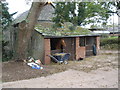
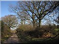
Kentisbeare: Allhallows Farm
Looking north east to farm barns from the lane to Allercombe
Image: © Martin Bodman
Taken: 29 Mar 2006
0.09 miles
5
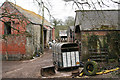
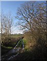
Lane to Allhallows Farm
The lane shown in Image runs past trees. The farm is just around the corner.
Image: © Derek Harper
Taken: 3 Feb 2012
0.12 miles
6
Green lane to Ashill
A very bendy lane with public access, here with ice along the ruts.
Image: © Derek Harper
Taken: 3 Feb 2012
0.19 miles
7

Green lane to Ashill
A closer view of the icy track shown in Image
Image: © Derek Harper
Taken: 3 Feb 2012
0.19 miles
8
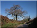
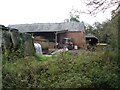
Lane to Allhallows Farm
The lane passes a pair of trees as it reaches the top of a rise.
Image: © Derek Harper
Taken: 3 Feb 2012
0.21 miles
9
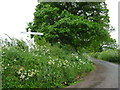
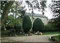
Mid Devon : Country Road
A country road and signpost between Ashill and Blackborough.
Image: © Lewis Clarke
Taken: 29 May 2010
0.22 miles
