IMAGES TAKEN NEAR TO
Kentisbeare, CULLOMPTON, EX15 2EU
Introduction
This page details the photographs taken nearby to EX15 2EU by members of the Geograph project.
The Geograph project started in 2005 with the aim of publishing, organising and preserving representative images for every square kilometre of Great Britain, Ireland and the Isle of Man.

There are currently over 7.5m images from over14,400 individuals and you can help contribute to the project by visiting https://www.geograph.org.uk
Image Map
Images are licensed for reuse under creativecommons.org/licenses/by-sa/2.0
Notes
- Clicking on the map will re-center to the selected point.
- The higher the marker number, the further away the image location is from the centre of the postcode.
Image Listing (3 Images Found)
Images are licensed for reuse under creativecommons.org/licenses/by-sa/2.0
Image
Details
Distance
1
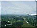
East Devon : Aerial View of Airfield, Woodlands & Dunkeswell
You get some really nice views from up here.
Image: © Lewis Clarke
Taken: 30 May 2010
0.14 miles
2
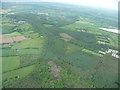
East Devon : Knowles Wood & Surroundings
From a glider looking down into the woodlands below.
Image: © Lewis Clarke
Taken: 30 May 2010
0.15 miles
3

View from Orway towards Knowles Wood
A quiet corner in rolling wooded countryside.
Image: © Sarah Smith
Taken: 21 Jun 2009
0.23 miles