IMAGES TAKEN NEAR TO
Kentisbeare, CULLOMPTON, EX15 2BU
Introduction
This page details the photographs taken nearby to EX15 2BU by members of the Geograph project.
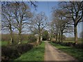
The Geograph project started in 2005 with the aim of publishing, organising and preserving representative images for every square kilometre of Great Britain, Ireland and the Isle of Man.

There are currently over 7.5m images from over14,400 individuals and you can help contribute to the project by visiting https://www.geograph.org.uk
Image Map
Images are licensed for reuse under creativecommons.org/licenses/by-sa/2.0
Notes
- Clicking on the map will re-center to the selected point.
- The higher the marker number, the further away the image location is from the centre of the postcode.
Image Listing (15 Images Found)
Images are licensed for reuse under creativecommons.org/licenses/by-sa/2.0
Image
Details
Distance
2
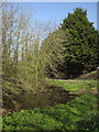
Pond at Aller Cross
On the northwest side of Image, at the edge of a wood. The conifers line the east side of the road to Horn Cross.
Image: © Derek Harper
Taken: 24 Mar 2012
0.06 miles
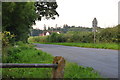
3

Kentisbeare : Aller Cross
Looking along the road at the junction.
Image: © Lewis Clarke
Taken: 8 Nov 2021
0.06 miles
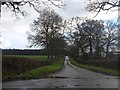
4
Mid Devon : Country Lane
A country lane seen at Aller Cross in Mid Devon.
Image: © Lewis Clarke
Taken: 24 Jul 2014
0.07 miles
5

Aller Cross
A meeting of country roads beneath oak trees. Straight ahead is the road shown in reverse in Image, passing a twin-gabled house near Kentismoor Farm.
Image: © Derek Harper
Taken: 24 Mar 2012
0.07 miles
6

Aller Cross
A view of Image from the lane from Clarke's Thorne. Past the conifers shown in Image is a glimpse of the former Green's Farm at Aller http://www.britishlistedbuildings.co.uk/en-95730-aller-restaurant-kentisbeare .
Image: © Derek Harper
Taken: 24 Mar 2012
0.07 miles
7

Mid Devon : Aller Cross
Looking across Aller Cross in Mid Devon.
Image: © Lewis Clarke
Taken: 24 Jul 2014
0.07 miles
8
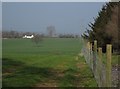
Road south of Aller Cross
Many of the roads in this area run in straight lines across the flat landscape.
Image: © David Smith
Taken: 15 Dec 2012
0.10 miles
9
Approaching Aller Cross
With the scene in Image further down the lane from Clarke's Thorne.
Image: © Derek Harper
Taken: 24 Mar 2012
0.10 miles
10
View alongside wood at Aller
From beside the gateway on the left of the road in Image, looking along the edge of the plantation. The pylon and isolated tree are in Image, and the white Newland Farm is in Image
Image: © Derek Harper
Taken: 24 Mar 2012
0.12 miles