IMAGES TAKEN NEAR TO
Horn Road, CULLOMPTON, EX15 2AX
Introduction
This page details the photographs taken nearby to Horn Road, EX15 2AX by members of the Geograph project.
The Geograph project started in 2005 with the aim of publishing, organising and preserving representative images for every square kilometre of Great Britain, Ireland and the Isle of Man.

There are currently over 7.5m images from over14,400 individuals and you can help contribute to the project by visiting https://www.geograph.org.uk
Image Map (Loading...)


Getting Data...Please wait
Leaflet Map data © OpenStreetMap
Images are licensed for reuse under creativecommons.org/licenses/by-sa/2.0
Notes
- Clicking on the map will re-center to the selected point.
- The higher the marker number, the further away the image location is from the centre of the postcode.
Image Listing (3 Images Found)
Images are licensed for reuse under creativecommons.org/licenses/by-sa/2.0
Image
Details
Distance
1
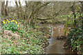
Kentisbeare: leat to Newland Farm
By Square Oak. The leat has been in existence since 1299 and provided the Newland Farm water supply. It was probably used for irrigation too. In the 19th century it also powered a waterwheel at the farm. The leat runs from Goodiford Mill and is about 1 mile 550 yards long. [Sources: Helen Barrett. Our Heritage. A History of Kentisbeare and Blackborough, privately published, 1977, 13-15; Devon Record Office – DRO 1926B/W/ET/6/13 – and Geoff Cann, the owner of Newland in 2003]
Image: © Martin Bodman
Taken: 29 Mar 2006
0.07 miles
2
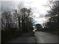
Bare trees in Horn Road near Horn House
The narrow road has been widened in places such as this to provide on-road parking.
Image: © David Smith
Taken: 15 Dec 2012
0.08 miles
3
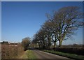
Horn Road
The roadside trees (the first few of which are inImage), and the house at Culm Leigh, can be seen in the background of Image
Image: © Derek Harper
Taken: 3 Feb 2012
0.18 miles