IMAGES TAKEN NEAR TO
Kentisbeare, CULLOMPTON, EX15 2AS
Introduction
This page details the photographs taken nearby to EX15 2AS by members of the Geograph project.
The Geograph project started in 2005 with the aim of publishing, organising and preserving representative images for every square kilometre of Great Britain, Ireland and the Isle of Man.

There are currently over 7.5m images from over14,400 individuals and you can help contribute to the project by visiting https://www.geograph.org.uk
Image Map (Loading...)


Getting Data...Please wait
Leaflet Map data © OpenStreetMap
Images are licensed for reuse under creativecommons.org/licenses/by-sa/2.0
Notes
- Clicking on the map will re-center to the selected point.
- The higher the marker number, the further away the image location is from the centre of the postcode.
Image Listing (15 Images Found)
Images are licensed for reuse under creativecommons.org/licenses/by-sa/2.0
Image
Details
Distance
1
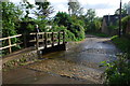
Goodiford Farm Ford
This setted ford is found at Goodisford Farm.
Image: © John Walton
Taken: 20 Sep 2013
0.03 miles
3
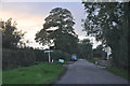
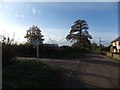
Mid Devon : Goodiford Cross
Heading along the road towards Goodiford Cross.
Image: © Lewis Clarke
Taken: 17 Oct 2013
0.04 miles
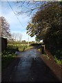
4

Ford, footbridge and Goodiford Farm
The view from the other side is at Image
Image: © David Smith
Taken: 21 Jul 2016
0.04 miles
7

Entrance to fishery at Goodiford Mill
The fishery also has a small caravan site
Image: © David Smith
Taken: 17 Nov 2011
0.06 miles
8

Kentisbeare: Goodiford Mill Fishery
One of several ponds on the site which offers coarse and trout fishing
Image: © Martin Bodman
Taken: 3 Mar 2006
0.09 miles
9
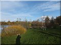
One of the fishing lakes at Goodiford Mill
Image: © David Smith
Taken: 17 Nov 2011
0.10 miles
