IMAGES TAKEN NEAR TO
Langford, CULLOMPTON, EX15 1RF
Introduction
This page details the photographs taken nearby to EX15 1RF by members of the Geograph project.
The Geograph project started in 2005 with the aim of publishing, organising and preserving representative images for every square kilometre of Great Britain, Ireland and the Isle of Man.

There are currently over 7.5m images from over14,400 individuals and you can help contribute to the project by visiting https://www.geograph.org.uk
Image Map (Loading...)


Getting Data...Please wait
Leaflet Map data © OpenStreetMap
Images are licensed for reuse under creativecommons.org/licenses/by-sa/2.0
Notes
- Clicking on the map will re-center to the selected point.
- The higher the marker number, the further away the image location is from the centre of the postcode.
Image Listing (6 Images Found)
Images are licensed for reuse under creativecommons.org/licenses/by-sa/2.0
Image
Details
Distance

2
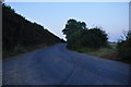
Mid Devon : Country Lane
A small country lane heading through the countryside.
Image: © Lewis Clarke
Taken: 24 Jul 2014
0.18 miles
3

Mid Devon : Grassy Field
A grassy field in the Mid Devon countryside.
Image: © Lewis Clarke
Taken: 24 Jul 2014
0.19 miles
4

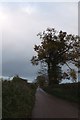
Minor road to Plymtree from Langford Green
The road follows field boundaries; beside the distant tree it turns through 90 degrees to the left and almost immediately turns right
Image: © David Smith
Taken: 4 Dec 2011
0.20 miles
5
Minor road to Plymtree from Langford Green
Image: © David Smith
Taken: 4 Dec 2011
0.21 miles
6
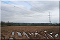
Cullompton: overhead power line near Langford
Looking south east. A second power line runs to the east
Image: © Martin Bodman
Taken: 21 Mar 2006
0.25 miles