IMAGES TAKEN NEAR TO
CULLOMPTON, EX15 1NG
Introduction
This page details the photographs taken nearby to EX15 1NG by members of the Geograph project.
The Geograph project started in 2005 with the aim of publishing, organising and preserving representative images for every square kilometre of Great Britain, Ireland and the Isle of Man.

There are currently over 7.5m images from over14,400 individuals and you can help contribute to the project by visiting https://www.geograph.org.uk
Image Map
Images are licensed for reuse under creativecommons.org/licenses/by-sa/2.0
Notes
- Clicking on the map will re-center to the selected point.
- The higher the marker number, the further away the image location is from the centre of the postcode.
Image Listing (34 Images Found)
Images are licensed for reuse under creativecommons.org/licenses/by-sa/2.0
Image
Details
Distance
1
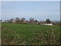
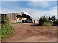
Rull Farm and Little Rull seen across field
There is a cluster of houses around the farm along Rull Lane
Image: © David Smith
Taken: 23 Mar 2012
0.03 miles
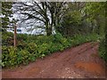
3
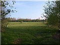
Meadow near Rull
Seen from Rull Lane, the meadow is bounded by the Rull Leat.
Image: © Derek Harper
Taken: 22 Apr 2010
0.08 miles
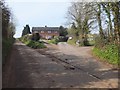
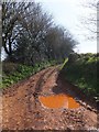
4
Rull Farm
Seen from Cullompton Bridleway 8. Rull Lane used to run through the farm; now the through road bends past it, as you can see.
Image: © Derek Harper
Taken: 22 Apr 2010
0.10 miles

9
Cullompton: Danes Mead
A cul-de-sac, part of a recent housing development at the north end of the town. Street names include Saxon Way and Plantagenet Drive
Image: © Martin Bodman
Taken: 23 Oct 2005
0.18 miles
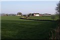
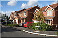
10
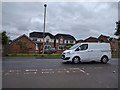
Houses and van on the edge of Cullompton
Image: © Rob Purvis
Taken: 18 May 2016
0.19 miles