IMAGES TAKEN NEAR TO
Buller Close, CULLOMPTON, EX15 1GF
Introduction
This page details the photographs taken nearby to Buller Close, EX15 1GF by members of the Geograph project.
The Geograph project started in 2005 with the aim of publishing, organising and preserving representative images for every square kilometre of Great Britain, Ireland and the Isle of Man.

There are currently over 7.5m images from over14,400 individuals and you can help contribute to the project by visiting https://www.geograph.org.uk
Image Map
Images are licensed for reuse under creativecommons.org/licenses/by-sa/2.0
Notes
- Clicking on the map will re-center to the selected point.
- The higher the marker number, the further away the image location is from the centre of the postcode.
Image Listing (155 Images Found)
Images are licensed for reuse under creativecommons.org/licenses/by-sa/2.0
Image
Details
Distance
1

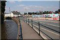
Path, Cullompton
In the foreground are railings by the watercourse mentioned at Image The path, which passes near the flats shown in that image, used to accompany the Mill race for some distance, but now is truncated by Millennium Way.
Image: © Derek Harper
Taken: 30 Jun 2015
0.06 miles
2

Path, Cullompton
A reverse view of Image], with the same oak, and houses on Hawkins Place visible on the right.
Image: © Derek Harper
Taken: 30 Jun 2015
0.07 miles
3
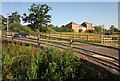
Cullompton: mill leat
The leat is retained by a wall, which also serves as a footpath, above Station Road, although Cullompton’s station went long ago in the Beeching cuts. It once powered waterwheels or turbines at Higher, Middle and Lower Mills. The new Tesco supermarket site is across the road and the entrance will be at the new junction with the Northern Distributor Road, by the Weary Traveller inn and past the houses in this view
Image: © Martin Bodman
Taken: 17 Apr 2008
0.07 miles
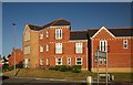
4
Cul-de-sac, Millennium Way, Cullompton
This little hammerhead off the new through road serves mainly as a vehicle route to parking for the flats shown in Image The car is parked in the opposite part of the hammerhead. The building behind is a block of flats by the junction of Millennium Way and Drake Close. Immediately in front of the camera is a watercourse that links the Mill Race with the Spratford Stream.
Image: © Derek Harper
Taken: 30 Jun 2015
0.07 miles
5
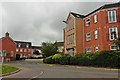
Housing estate to the north of Cullompton
Image: © Roger Cornfoot
Taken: 22 Jun 2016
0.08 miles
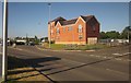
6
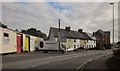
Station Road, Cullompton
Business units on the left, then a row of terraced house, and then a recent block of flats (also shown in Image] and Image]). This is the B3181.
Image: © Derek Harper
Taken: 21 Jul 2015
0.08 miles
7
Flats, Millennium Way, Cullompton
Looking across the southern end of the road at its junction with Station Road, a reverse view of Image
Image: © Derek Harper
Taken: 30 Jun 2015
0.08 miles
8
Flats, Millennium Way, Cullompton
Image: © Derek Harper
Taken: 30 Jun 2015
0.08 miles
9
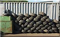
Tyres, Cullompton
A wall of tyres also vixible in Image
Image: © Derek Harper
Taken: 15 May 2016
0.08 miles
10
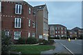
Cullompton : Millennium Way
A newer part of Cullompton with modern flats.
Image: © Lewis Clarke
Taken: 8 Aug 2013
0.09 miles