IMAGES TAKEN NEAR TO
Hutchings Drive, EX1 4AP
Introduction
This page details the photographs taken nearby to Hutchings Drive, EX1 4AP by members of the Geograph project.
The Geograph project started in 2005 with the aim of publishing, organising and preserving representative images for every square kilometre of Great Britain, Ireland and the Isle of Man.

There are currently over 7.5m images from over14,400 individuals and you can help contribute to the project by visiting https://www.geograph.org.uk
Image Map
Images are licensed for reuse under creativecommons.org/licenses/by-sa/2.0
Notes
- Clicking on the map will re-center to the selected point.
- The higher the marker number, the further away the image location is from the centre of the postcode.
Image Listing (50 Images Found)
Images are licensed for reuse under creativecommons.org/licenses/by-sa/2.0
Image
Details
Distance
1
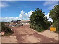
Housing development by Tithebarn Lane
The cycle track on the right is Tithebarn Lane
Image: © David Smith
Taken: 31 May 2022
0.04 miles
2
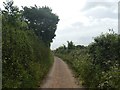
Approaching the eastern end of Tithebarn Lane
Image: © David Smith
Taken: 22 May 2020
0.06 miles
3
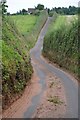
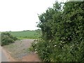
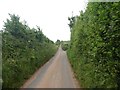
East Devon : Mosshayne Lane
Looking along Mosshayne Lane.
Image: © Lewis Clarke
Taken: 4 Aug 2015
0.06 miles
7
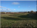
Housing development at Tithe Barn, Pinhoe and Lidl warehouse
Image: © David Smith
Taken: 5 Jan 2022
0.08 miles
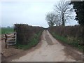
8
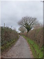
Tithebarn Lane
This lane is now blocked for through traffic owing to large housing developments in progress in the area, which have caused a reconfiguration of the road layout.
Image: © Rod Allday
Taken: 6 Dec 2018
0.09 miles
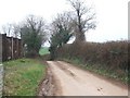
10
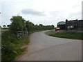
Mill Lane, Clyst Honiton, and farm buildings
Image: © David Smith
Taken: 22 May 2020
0.09 miles