IMAGES TAKEN NEAR TO
Stoney Lane, HONITON, EX14 9TU
Introduction
This page details the photographs taken nearby to Stoney Lane, EX14 9TU by members of the Geograph project.
The Geograph project started in 2005 with the aim of publishing, organising and preserving representative images for every square kilometre of Great Britain, Ireland and the Isle of Man.

There are currently over 7.5m images from over14,400 individuals and you can help contribute to the project by visiting https://www.geograph.org.uk
Image Map
Images are licensed for reuse under creativecommons.org/licenses/by-sa/2.0
Notes
- Clicking on the map will re-center to the selected point.
- The higher the marker number, the further away the image location is from the centre of the postcode.
Image Listing (6 Images Found)
Images are licensed for reuse under creativecommons.org/licenses/by-sa/2.0
Image
Details
Distance
1
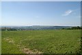
View from Honiton Golf Club
View from Honiton Golf Club towards Hembury Fort.
Image: © Kevin Hale
Taken: 16 Jul 2006
0.06 miles
2
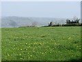
View over Honiton
Looking off the East Devon Plateau. Beyond the unseen town of Honiton, the greensand plateau continues as the Blackdown Hills.
Image: © Richard Webb
Taken: 20 Apr 2011
0.11 miles
3
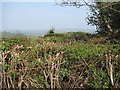
Thick hedges
A junction of some very wide hedgerows.
Image: © Richard Webb
Taken: 20 Apr 2011
0.13 miles
4
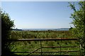
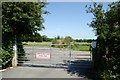
View through gateway near Honiton Golf Club
View through gateway near Honiton Golf Club, Devon.
Image: © Kevin Hale
Taken: 16 Jul 2006
0.15 miles
5
Honiton Golf Club Practice Area
Honiton Golf Club Practice Area Farway Road, Honiton.
Image: © Kevin Hale
Taken: 16 Jul 2006
0.19 miles
6

An avenue of trees on the minor road from Farway to Honiton
Image: © David Smith
Taken: 1 Dec 2011
0.21 miles