IMAGES TAKEN NEAR TO
Cotleigh, HONITON, EX14 9SY
Introduction
This page details the photographs taken nearby to EX14 9SY by members of the Geograph project.
The Geograph project started in 2005 with the aim of publishing, organising and preserving representative images for every square kilometre of Great Britain, Ireland and the Isle of Man.

There are currently over 7.5m images from over14,400 individuals and you can help contribute to the project by visiting https://www.geograph.org.uk
Image Map
Images are licensed for reuse under creativecommons.org/licenses/by-sa/2.0
Notes
- Clicking on the map will re-center to the selected point.
- The higher the marker number, the further away the image location is from the centre of the postcode.
Image Listing (4 Images Found)
Images are licensed for reuse under creativecommons.org/licenses/by-sa/2.0
Image
Details
Distance
1
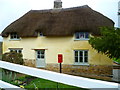
Orange Way in Devon and Torbay (440)
Southcote Farm has its very own Royal Mail pillarbox but no collection times are shown.
Image: © Shazz
Taken: 18 Apr 2012
0.01 miles
2
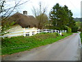
Orange Way in Devon and Torbay (439)
This was taken going down Southcote Lane approaching the farmhouse.
Image: © Shazz
Taken: 18 Apr 2012
0.01 miles
3
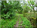
Orange Way in Devon and Torbay (441)
This very stony track leads down to the stream below Southcote Farm.
Image: © Shazz
Taken: 18 Apr 2012
0.21 miles
4
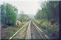
Honiton Bank.
Viewed from the rear cab of a Westbound train in 1999, the small derelict building on the left was once a signal box. When the line was two tracks there was an escape siding to the right to stop runaway wagons from running all the way down the bank. It is not known if this ever happened.
Image: © Clive Warneford
Taken: Unknown
0.22 miles