IMAGES TAKEN NEAR TO
Offwell, HONITON, EX14 9SN
Introduction
This page details the photographs taken nearby to EX14 9SN by members of the Geograph project.
The Geograph project started in 2005 with the aim of publishing, organising and preserving representative images for every square kilometre of Great Britain, Ireland and the Isle of Man.

There are currently over 7.5m images from over14,400 individuals and you can help contribute to the project by visiting https://www.geograph.org.uk
Image Map
Images are licensed for reuse under creativecommons.org/licenses/by-sa/2.0
Notes
- Clicking on the map will re-center to the selected point.
- The higher the marker number, the further away the image location is from the centre of the postcode.
Image Listing (5 Images Found)
Images are licensed for reuse under creativecommons.org/licenses/by-sa/2.0
Image
Details
Distance
2
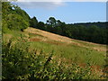
Field at Colwell
A field sloping down to the Offwell Brook from the lane between Offwell and Colwell.
Image: © Derek Harper
Taken: 12 Jul 2006
0.13 miles
3

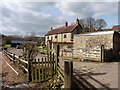
West Colwell: Lane to Colwell Barton looking East
A typical Devonshire lane, narrow with high field hedges.
Image: © Trevor Durritt
Taken: 31 May 2007
0.21 miles

5
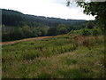
Offwell Brook valley at West Colwell
Looking up the valley from the lane past West Colwell, with Aplin's Common on the left.
Image: © Derek Harper
Taken: 12 Jul 2006
0.24 miles