IMAGES TAKEN NEAR TO
Offwell, HONITON, EX14 9SE
Introduction
This page details the photographs taken nearby to EX14 9SE by members of the Geograph project.
The Geograph project started in 2005 with the aim of publishing, organising and preserving representative images for every square kilometre of Great Britain, Ireland and the Isle of Man.

There are currently over 7.5m images from over14,400 individuals and you can help contribute to the project by visiting https://www.geograph.org.uk
Image Map
Images are licensed for reuse under creativecommons.org/licenses/by-sa/2.0
Notes
- Clicking on the map will re-center to the selected point.
- The higher the marker number, the further away the image location is from the centre of the postcode.
Image Listing (18 Images Found)
Images are licensed for reuse under creativecommons.org/licenses/by-sa/2.0
Image
Details
Distance
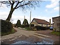
2
Junction, Eastleigh
See Image]; just 800 metres further on, another noisy dog circles me. Featherbed Lane crosses a lane from the A35 to Offwell here, but turns into an unmetalled green lane as it does so.
Image: © Derek Harper
Taken: 28 Aug 2012
0.07 miles
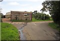
3

Eastleigh Farm
See Image; this is the view to the left, with the vociferois dog in the middle of the road, and the farm on the right of the lane from Offwell to the A35.
Image: © Derek Harper
Taken: 28 Aug 2012
0.07 miles
4
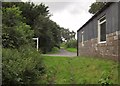
Featherbed Lane
The green lane reaches the crossroads at Eastleigh (see Image) and continues as a metalled road. The signpost points to Offwell - nothing else suggested.
Image: © Derek Harper
Taken: 28 Aug 2012
0.07 miles
5

Featherbed Lane
A green lane that has to be shared, for most of its route, with a watercourse of some sort.
Image: © Derek Harper
Taken: 28 Aug 2012
0.08 miles
6

Featherbed Lane
A further view of the green lane shown in Image, with a stream rather taking over. This is quite slippery. Nice ferns.
Image: © Derek Harper
Taken: 28 Aug 2012
0.10 miles
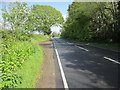
7

A35 crossroads on Mount Pleasant near Offwell
Image: © David Smith
Taken: 6 Dec 2012
0.10 miles

10
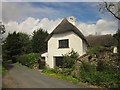
Cottage by the A35
A view of Image from the other direction. Batts Close is thought to have C16 origins, though it's not listed. In the foreground is Featherbed Lane, about to join the A35 in a few metres as shown in Image
Image: © Derek Harper
Taken: 28 Aug 2012
0.20 miles