IMAGES TAKEN NEAR TO
Pipers Place, HONITON, EX14 9RJ
Introduction
This page details the photographs taken nearby to Pipers Place, EX14 9RJ by members of the Geograph project.
The Geograph project started in 2005 with the aim of publishing, organising and preserving representative images for every square kilometre of Great Britain, Ireland and the Isle of Man.

There are currently over 7.5m images from over14,400 individuals and you can help contribute to the project by visiting https://www.geograph.org.uk
Image Map
Images are licensed for reuse under creativecommons.org/licenses/by-sa/2.0
Notes
- Clicking on the map will re-center to the selected point.
- The higher the marker number, the further away the image location is from the centre of the postcode.
Image Listing (23 Images Found)
Images are licensed for reuse under creativecommons.org/licenses/by-sa/2.0
Image
Details
Distance
1
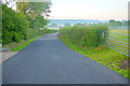
The Lane to Beacon Hill
This lane runs north out of the village of Upottery past Harvestwood Farm. This is the view back down to the village in the valley.
Image: © Nigel Mykura
Taken: 7 Aug 2015
0.10 miles
2
Dawn near Harvestwood Farm
The sun rises behind the flagpole with its limp flag of this solitary house just south of the farm on the road to Upottery.
Image: © Nigel Mykura
Taken: 7 Aug 2015
0.12 miles
3
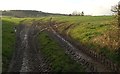
Field north of Upottery
Tractor tyre tracks climb into a pasture by the road to Beacon Hill, by Milestone Cottage.
Image: © Derek Harper
Taken: 26 Jan 2012
0.13 miles
4

Buildings at Upottery
The shadowed wall is opposite the junction of roads arriving from Mattys Cross and Churchinford. On the extreme right is the Sidmouth Arms.
Image: © Derek Harper
Taken: 22 May 2012
0.15 miles

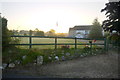
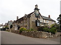
6
The Sidmouth Arms Pub in Upottery
A view of the front of the Sidmouth Arms Pub in Upottery, Devon as viewed from the road that runs through the village.
Image: © John P Reeves
Taken: 21 Jul 2023
0.19 miles
8
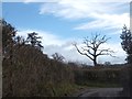
Dead tree in field west of Upottery
This skeleton of a tree is in a field which extends from this minor road to the western edge of the village. The field has an irregular shape, partly because at least one hedge has been removed
Image: © David Smith
Taken: 1 Jan 2013
0.19 miles
9

The Old Coach House, Upottery
Dates from the 1870s https://historicengland.org.uk/listing/the-list/list-entry/1169196
Image: © Jonathan Thacker
Taken: 18 Sep 2018
0.19 miles
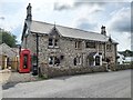
10

Upottery: Sidmouth Arms
An inn offering bed and breakfast. Looking north-north-east
Image: © Martin Bodman
Taken: 2 Jun 2006
0.19 miles