IMAGES TAKEN NEAR TO
Upottery, HONITON, EX14 9RH
Introduction
This page details the photographs taken nearby to EX14 9RH by members of the Geograph project.
The Geograph project started in 2005 with the aim of publishing, organising and preserving representative images for every square kilometre of Great Britain, Ireland and the Isle of Man.

There are currently over 7.5m images from over14,400 individuals and you can help contribute to the project by visiting https://www.geograph.org.uk
Image Map
Images are licensed for reuse under creativecommons.org/licenses/by-sa/2.0
Notes
- Clicking on the map will re-center to the selected point.
- The higher the marker number, the further away the image location is from the centre of the postcode.
Image Listing (13 Images Found)
Images are licensed for reuse under creativecommons.org/licenses/by-sa/2.0
Image
Details
Distance
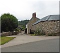
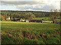
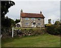
3
Upottery: overlooking Glebe Farm
Barns converted to residences. Looking south east
Image: © Martin Bodman
Taken: 2 Jun 2006
0.02 miles
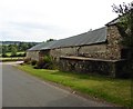
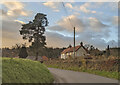
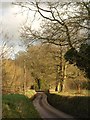
5
Glebe Farm
A wide view of the scene in Image, from the road winding down into the Otter valley from Mattys Cross.
Image: © Derek Harper
Taken: 26 Jan 2012
0.05 miles
8
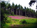
A density of Foxgloves near Upottery
Just passing the gate the intense colour caught my eye and on investigating further found there to be an area of foxgloves growing in great profusion nestling into the bank and sheltered by the conifers.
Image: © Sarah Smith
Taken: 21 Jun 2009
0.18 miles
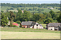
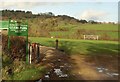
9
Road past Glebe Park
The lane to Upottery seen from the point where Image was taken.
Image: © Derek Harper
Taken: 26 Jan 2012
0.19 miles
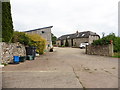
10
Glebe Park, Upottery
Useful historical information given on the noticeboard; the playing fields were opened on 4th August 2001. Behind is the valley of a tributary of the Otter.
Image: © Derek Harper
Taken: 26 Jan 2012
0.20 miles