IMAGES TAKEN NEAR TO
Upottery, HONITON, EX14 9QX
Introduction
This page details the photographs taken nearby to EX14 9QX by members of the Geograph project.
The Geograph project started in 2005 with the aim of publishing, organising and preserving representative images for every square kilometre of Great Britain, Ireland and the Isle of Man.

There are currently over 7.5m images from over14,400 individuals and you can help contribute to the project by visiting https://www.geograph.org.uk
Image Map
Images are licensed for reuse under creativecommons.org/licenses/by-sa/2.0
Notes
- Clicking on the map will re-center to the selected point.
- The higher the marker number, the further away the image location is from the centre of the postcode.
Image Listing (11 Images Found)
Images are licensed for reuse under creativecommons.org/licenses/by-sa/2.0
Image
Details
Distance
1

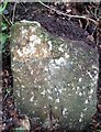
Old Milestone near Beacon Hill, Upottery Parish
Carved stone post by the UC road, in parish of UPOTTERY (EAST DEVON District), Beacon Hill, 20m North of drive to garage of cottage, 200m South of Tiphayes Farm, in the soil bank hard by the road edge, on Northwest side of road. Honiton gabled stone, erected by the Honiton turnpike trust in the 19th century.
Inscription reads:-
HONI(TON)
6
TAUNTON
11
Grade II listed.
List Entry Number: 1333664 https://historicengland.org.uk/listing/the-list/list-entry/1333664
Milestone Society National ID: DV_HNTA06.
Image: © A Rosevear
Taken: 24 Nov 2008
0.06 miles
2
Old Milestone near Beacon Hill, Upottery Parish
Carved stone post by the UC road, in parish of UPOTTERY (EAST DEVON District), Beacon Hill, 20m North of drive to garage of cottage, 200m South of Tiphayes Farm, in the soil bank hard by the road edge, on Northwest side of road. Honiton gabled stone, erected by the Honiton turnpike trust in the 19th century.
Inscription reads:-
HONI(TON)
6
TAUNTON
11
Grade II listed.
List Entry Number: 1333664 https://historicengland.org.uk/listing/the-list/list-entry/1333664
Milestone Society National ID: DV_HNTA06.
Image: © Nick Savage
Taken: 1 Jul 2020
0.06 miles
3
Upottery: by a turning to Beacon Hill
Looking north east. Wild deer are quite common in this neck of the woods
Image: © Martin Bodman
Taken: 2 Jun 2006
0.15 miles
4

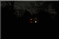
Upottery : Woodland
The Wolf Moon shines brightly above the woods.
Image: © Lewis Clarke
Taken: 10 Jan 2020
0.17 miles
5
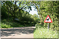
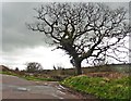
Road Round Beacon Hill
This is the minor road from Upottery to Moonhayes. The old road climbs over the steep rise and on to the top of the hill. This more recent road follows the contours round it. The old road is still there as an ORPA. The road dropping down to the right goes to Tiphayes.
Image: © Nigel Mykura
Taken: 7 Aug 2015
0.19 miles
6
Upottery : Track
At the end of the track, you can make out the windows of a house.
Image: © Lewis Clarke
Taken: 10 Jan 2020
0.19 miles

9
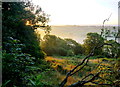
Dawn Over Tiphayes
View east over the upper valley of the River Otter just as the sun is rising over Birch Hill near Yarcombe on the eastern side of the valley.
Image: © Nigel Mykura
Taken: 7 Aug 2015
0.22 miles
10

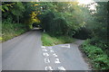
ORPA near Charleshayes Farmhouse
There are numerous unmetalled roads and lanes, such as this one, in this area linking the farms and hamlets, and many of them are ORPA's (other routes with public access).
Image: © Nigel Mykura
Taken: 7 Aug 2015
0.22 miles