IMAGES TAKEN NEAR TO
Upottery, HONITON, EX14 9PY
Introduction
This page details the photographs taken nearby to EX14 9PY by members of the Geograph project.
The Geograph project started in 2005 with the aim of publishing, organising and preserving representative images for every square kilometre of Great Britain, Ireland and the Isle of Man.

There are currently over 7.5m images from over14,400 individuals and you can help contribute to the project by visiting https://www.geograph.org.uk
Image Map
Images are licensed for reuse under creativecommons.org/licenses/by-sa/2.0
Notes
- Clicking on the map will re-center to the selected point.
- The higher the marker number, the further away the image location is from the centre of the postcode.
Image Listing (24 Images Found)
Images are licensed for reuse under creativecommons.org/licenses/by-sa/2.0
Image
Details
Distance
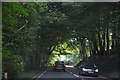
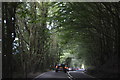
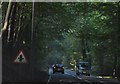
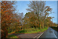
2
Upottery: on Reddick?s Hill
The A30 London-Exeter Trunk Road climbs through woods above the Otter valley. Turn left for Honiton and Exeter. The route can become heavily congested in summertime. Looking south west
Image: © Martin Bodman
Taken: 25 Nov 2006
0.08 miles
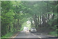
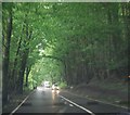
3
Upottery: approaching the A30
On Reddick’s Hill, looking south west. Turn left for Honiton and Exeter
Image: © Martin Bodman
Taken: 25 Nov 2006
0.09 miles
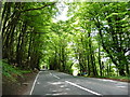
7
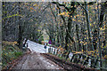
Upottery : Viney Lane
Looking along Viney Lane.
Image: © Lewis Clarke
Taken: 13 Nov 2020
0.12 miles
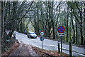
8
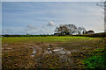
Upottery : Grassy Field
A grassy field.
Image: © Lewis Clarke
Taken: 13 Nov 2020
0.12 miles