IMAGES TAKEN NEAR TO
Old Chard Road, HONITON, EX14 9NN
Introduction
This page details the photographs taken nearby to Old Chard Road, EX14 9NN by members of the Geograph project.
The Geograph project started in 2005 with the aim of publishing, organising and preserving representative images for every square kilometre of Great Britain, Ireland and the Isle of Man.

There are currently over 7.5m images from over14,400 individuals and you can help contribute to the project by visiting https://www.geograph.org.uk
Image Map
Images are licensed for reuse under creativecommons.org/licenses/by-sa/2.0
Notes
- Clicking on the map will re-center to the selected point.
- The higher the marker number, the further away the image location is from the centre of the postcode.
Image Listing (17 Images Found)
Images are licensed for reuse under creativecommons.org/licenses/by-sa/2.0
Image
Details
Distance
1

Monkton: sawmills
Allan Bright & Son sawmills. Looking east-south-east
Image: © Martin Bodman
Taken: 28 Jun 2006
0.04 miles
2
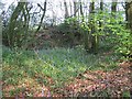
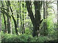
Bluebells, Old Chard Road
The narrow strip of beeches that protect the Old Chard Road.
Image: © Richard Webb
Taken: 20 Apr 2011
0.11 miles
3
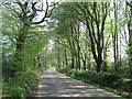
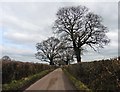
Old Chard Road
A road sticking to the plateau and running through a long beech stripwood.
Image: © Richard Webb
Taken: 20 Apr 2011
0.12 miles
4
Cleverhayes Lane
A reverse view of Image], taken from the next tree.
Image: © Derek Harper
Taken: 25 May 2013
0.14 miles
5
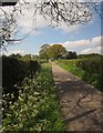
Cleverhayes Lane
The lane passes the entrance road to Whitehorn Farm and Lower Whitehorne.
Image: © Derek Harper
Taken: 25 May 2013
0.14 miles
7
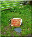
Orange Way in Devon and Torbay (435)
Somewhere along this lane was this charming "for sale" sign.
Image: © Shazz
Taken: 18 Apr 2012
0.15 miles
8
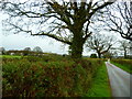
Beech woods, Old Chard Road
There is a strip of mature beeches either side of the hill top road.
Image: © Richard Webb
Taken: 20 Apr 2011
0.15 miles
9
Orange Way in Devon and Torbay (434)
This is the view along Cleverhayes Lane. The buildings on the left across the fields are in Old Chard Road.
Image: © Shazz
Taken: 18 Apr 2012
0.16 miles
10
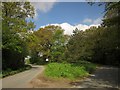
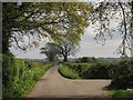
Junction at top of Northcote Hill
This is the junction shown in Image, with spring leaves out. Cleverhayes Lane, the road to the right, leads to Cotleigh and carries the Buzzard Route (regional cycle route 52), or along Hutgate Road to Tower Cross; the mainer road on the left, Old Chard Road, is for Cotleigh Bridge and Stockland.
Image: © Derek Harper
Taken: 25 May 2013
0.24 miles