IMAGES TAKEN NEAR TO
Yarcombe, HONITON, EX14 9LY
Introduction
This page details the photographs taken nearby to EX14 9LY by members of the Geograph project.
The Geograph project started in 2005 with the aim of publishing, organising and preserving representative images for every square kilometre of Great Britain, Ireland and the Isle of Man.

There are currently over 7.5m images from over14,400 individuals and you can help contribute to the project by visiting https://www.geograph.org.uk
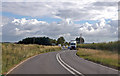
Image Map
Images are licensed for reuse under creativecommons.org/licenses/by-sa/2.0
Notes
- Clicking on the map will re-center to the selected point.
- The higher the marker number, the further away the image location is from the centre of the postcode.
Image Listing (9 Images Found)
Images are licensed for reuse under creativecommons.org/licenses/by-sa/2.0
Image
Details
Distance
2
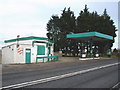
Deserted petrol station at Stopgate
The pumps still seemed operable. Perhaps it operates only through the sunmmer season.
Image: © Roger Cornfoot
Taken: 16 Feb 2009
0.12 miles


6

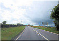
Lane past Crow Moor
The winding lane between Stopgate Cross on the A303 and Knapp Farm, seen as it twists past Crow Moor above the Otter valley.
Image: © Derek Harper
Taken: 21 Sep 2006
0.21 miles

9
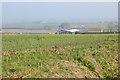
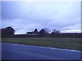
Oilseed rape, Croakham
See, there is more to ST2309 than tarmac seen through a windscreen.
Oilseed rape is coming into flower, 250m up on the Blackdown Hills.
Image: © Richard Webb
Taken: 9 Apr 2015
0.25 miles