IMAGES TAKEN NEAR TO
Stockland, HONITON, EX14 9LL
Introduction
This page details the photographs taken nearby to EX14 9LL by members of the Geograph project.
The Geograph project started in 2005 with the aim of publishing, organising and preserving representative images for every square kilometre of Great Britain, Ireland and the Isle of Man.

There are currently over 7.5m images from over14,400 individuals and you can help contribute to the project by visiting https://www.geograph.org.uk
Image Map
Images are licensed for reuse under creativecommons.org/licenses/by-sa/2.0
Notes
- Clicking on the map will re-center to the selected point.
- The higher the marker number, the further away the image location is from the centre of the postcode.
Image Listing (11 Images Found)
Images are licensed for reuse under creativecommons.org/licenses/by-sa/2.0
Image
Details
Distance
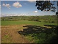
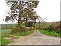
1
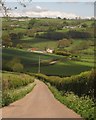
Lane to Long Bridge
A long descent from Road End Cross, here seen from the entrance to Trimshayes Farm. As the road bends left, it crosses into Image before passing Higher Longbridge, the farm in the centre, and crossing the Yarty. Some of the fields on the far slopes have a bocage-like quality, surrounded by trees.
Image: © Derek Harper
Taken: 16 May 2013
0.07 miles
3
Entrance to Trimshayes Farm
Placing Image], taken from the same spot, in wider context.
Image: © Derek Harper
Taken: 16 May 2013
0.11 miles
5
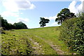
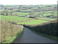
Steep Pastureland at Trimshayes Farm
This field is next to the minor road from Stockland to Yarcombe just north of Road End Cross
Image: © Nigel Mykura
Taken: 7 Aug 2015
0.12 miles
6
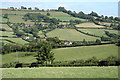
Stockland: the Yarty valley
Looking east-south-east near Trimshayes Farm
Image: © Martin Bodman
Taken: 27 Aug 2006
0.19 miles
7
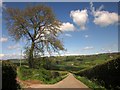
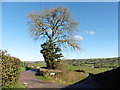
Field by Lye Lane
From beneath a pine where Lye Lane meets the road from Stockland to Yarcombe. The clump of trees surrounds a pond. Beyond is the Yarty valley.
Image: © Derek Harper
Taken: 16 May 2013
0.19 miles
9
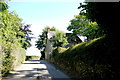
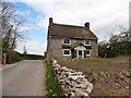
House next to Greasehayes Farm
This small cottage stands on a small triangle of land at Road End Cross
Image: © Nigel Mykura
Taken: 7 Aug 2015
0.20 miles