IMAGES TAKEN NEAR TO
Stockland, HONITON, EX14 9LG
Introduction
This page details the photographs taken nearby to EX14 9LG by members of the Geograph project.
The Geograph project started in 2005 with the aim of publishing, organising and preserving representative images for every square kilometre of Great Britain, Ireland and the Isle of Man.

There are currently over 7.5m images from over14,400 individuals and you can help contribute to the project by visiting https://www.geograph.org.uk
Image Map
Images are licensed for reuse under creativecommons.org/licenses/by-sa/2.0
Notes
- Clicking on the map will re-center to the selected point.
- The higher the marker number, the further away the image location is from the centre of the postcode.
Image Listing (5 Images Found)
Images are licensed for reuse under creativecommons.org/licenses/by-sa/2.0
Image
Details
Distance
2
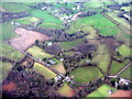
Golden Square at Shortmoor
Looking east from above Stockland.
Image: © M J Richardson
Taken: 11 Jan 2015
0.10 miles
4
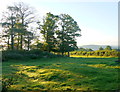
Rough Pasture , Royal Oak Cross
It is uncertain whether the name refers to a public house long since gone or another tree that a king hid in. There are no buildings near the cross roads now.
Image: © Nigel Mykura
Taken: 7 Aug 2015
0.24 miles
5

Tree-lined lane, north of Shortmoor Cross
Image: © Roger Cornfoot
Taken: 25 Apr 2009
0.25 miles