IMAGES TAKEN NEAR TO
Widworthy, HONITON, EX14 9JS
Introduction
This page details the photographs taken nearby to EX14 9JS by members of the Geograph project.
The Geograph project started in 2005 with the aim of publishing, organising and preserving representative images for every square kilometre of Great Britain, Ireland and the Isle of Man.

There are currently over 7.5m images from over14,400 individuals and you can help contribute to the project by visiting https://www.geograph.org.uk
Image Map
Images are licensed for reuse under creativecommons.org/licenses/by-sa/2.0
Notes
- Clicking on the map will re-center to the selected point.
- The higher the marker number, the further away the image location is from the centre of the postcode.
Image Listing (7 Images Found)
Images are licensed for reuse under creativecommons.org/licenses/by-sa/2.0
Image
Details
Distance
1
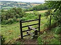
View from a Stile
A stile marking the public footpath on a hillside overlooking the valley of Umborne Brook near the village of Widsworthy in Devon.
Image: © John P Reeves
Taken: 4 Jul 2023
0.13 miles
2

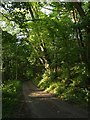
Lane to Widworthy
The no through lane from Halshayne Manor winds past Mountain Copse in morning sunlight (6:38) on its way towards Widworthy.
Image: © Derek Harper
Taken: 22 May 2007
0.15 miles

4
Lane through the woods
The narrow no through lane to Halshayne Manor Farm passes between Marsh Copse on the left and Mountain Copse on the right.
Image: © Derek Harper
Taken: 22 May 2007
0.22 miles
5
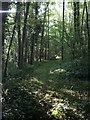
Marsh Copse
A narrow ride through a wood that drops down the side of the Umborne Brook valley.
Image: © Derek Harper
Taken: 22 May 2007
0.23 miles
7
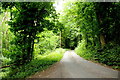
Road Through Mountain Copse
This is the minor road that is a dead end that runs from the hamlet of Widworthy to Halshayne Manor Farm
Image: © Nigel Mykura
Taken: 13 Jul 2019
0.25 miles