IMAGES TAKEN NEAR TO
Cotleigh, HONITON, EX14 9JB
Introduction
This page details the photographs taken nearby to EX14 9JB by members of the Geograph project.
The Geograph project started in 2005 with the aim of publishing, organising and preserving representative images for every square kilometre of Great Britain, Ireland and the Isle of Man.

There are currently over 7.5m images from over14,400 individuals and you can help contribute to the project by visiting https://www.geograph.org.uk
Image Map
Images are licensed for reuse under creativecommons.org/licenses/by-sa/2.0
Notes
- Clicking on the map will re-center to the selected point.
- The higher the marker number, the further away the image location is from the centre of the postcode.
Image Listing (7 Images Found)
Images are licensed for reuse under creativecommons.org/licenses/by-sa/2.0
Image
Details
Distance
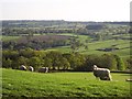
1
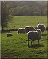
Sheep on Stockland Hill
Some woolly backsides by the straight road along the plateau.
Image: © Derek Harper
Taken: 22 May 2012
0.07 miles
2
Above Snodland
Sheep beside the Stockland Hill road.
Image: © Richard Webb
Taken: 9 Apr 2015
0.12 miles
3
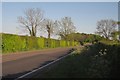
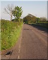
Stockland Hill
The straight road within sight of Royal Oak Cross, where it bends (slightly). Taken from the same spot as Image
Image: © Derek Harper
Taken: 22 May 2012
0.13 miles
4
Sheep on Stockland Hill
Image: © Derek Harper
Taken: 22 May 2012
0.15 miles
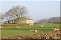
5

Stockland Hill at Lillington Farm
View south with the farm just off on the left. The road runs in a very straight line for 3.5 km from Royal Oak Cross to the A303.
Image: © Nigel Mykura
Taken: 7 Aug 2015
0.18 miles
6
Stockland Hill
The road runs straight for nearly 4 kilometres. Here it is seen from the turn into Lillington Farm.
Image: © Derek Harper
Taken: 22 May 2012
0.19 miles
7
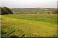
Field at Lillington Farm
Another view over the field shown on the right of Image, with the Corry Brook valley beyond.
Image: © Derek Harper
Taken: 22 May 2012
0.25 miles