IMAGES TAKEN NEAR TO
Cotleigh, HONITON, EX14 9JA
Introduction
This page details the photographs taken nearby to EX14 9JA by members of the Geograph project.
The Geograph project started in 2005 with the aim of publishing, organising and preserving representative images for every square kilometre of Great Britain, Ireland and the Isle of Man.

There are currently over 7.5m images from over14,400 individuals and you can help contribute to the project by visiting https://www.geograph.org.uk
Image Map
Images are licensed for reuse under creativecommons.org/licenses/by-sa/2.0
Notes
- Clicking on the map will re-center to the selected point.
- The higher the marker number, the further away the image location is from the centre of the postcode.
Image Listing (8 Images Found)
Images are licensed for reuse under creativecommons.org/licenses/by-sa/2.0
Image
Details
Distance
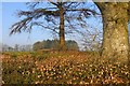
3
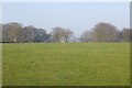
Barn Park
Field beside the Stockland Hill road. A flattish field with a steep slope beyond the trees.
Image: © Richard Webb
Taken: 9 Apr 2015
0.14 miles
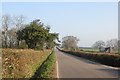
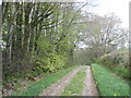
5
Thick hedges, Stockland Hill
Thick beech hedges are a feature of the high ground on the greensand plateau.
Image: © Richard Webb
Taken: 9 Apr 2015
0.20 miles
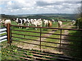
7
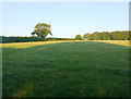
Fields at Barn Park Farm
The grass and clover in this pasture field at the side of Stockland Hill had been allowed to grow ready for stock.
Image: © Nigel Mykura
Taken: 7 Aug 2015
0.22 miles
8
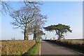
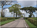
Stockland Hill
A long straight road along one of the tongues of high land extending south from the Blackdown Hills.
Image: © Richard Webb
Taken: 9 Apr 2015
0.23 miles