IMAGES TAKEN NEAR TO
Cotleigh, HONITON, EX14 9HQ
Introduction
This page details the photographs taken nearby to EX14 9HQ by members of the Geograph project.
The Geograph project started in 2005 with the aim of publishing, organising and preserving representative images for every square kilometre of Great Britain, Ireland and the Isle of Man.

There are currently over 7.5m images from over14,400 individuals and you can help contribute to the project by visiting https://www.geograph.org.uk
Image Map
Images are licensed for reuse under creativecommons.org/licenses/by-sa/2.0
Notes
- Clicking on the map will re-center to the selected point.
- The higher the marker number, the further away the image location is from the centre of the postcode.
Image Listing (8 Images Found)
Images are licensed for reuse under creativecommons.org/licenses/by-sa/2.0
Image
Details
Distance
3
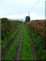
Orange Way in Devon and Torbay (437)
There's a pheasant flying over this unmetalled road.
Image: © Shazz
Taken: 18 Apr 2012
0.22 miles
4

View towards Stockland Hill TV Station
Image: © Roger Cornfoot
Taken: 21 Mar 2018
0.22 miles
5
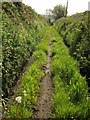
Southcote Lane
Further east along the route with public access shown in Image
Image: © Derek Harper
Taken: 25 May 2013
0.23 miles
6
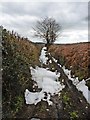
Southcote Lane
Following late winter snow. Seen here in warmer times: Image
Image: © Roger Cornfoot
Taken: 21 Mar 2018
0.24 miles
7
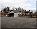
Cotleigh : Village Road
A road heading out from Cotleigh.
Image: © Lewis Clarke
Taken: 6 Sep 2017
0.24 miles
8

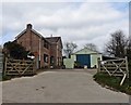
Cotleigh Recreation Ground
A large field with a children's play area , a carpark and also the village hall as well as the actual playing fields
Image: © Nigel Mykura
Taken: 7 Aug 2015
0.25 miles