IMAGES TAKEN NEAR TO
Cotleigh, HONITON, EX14 9HG
Introduction
This page details the photographs taken nearby to EX14 9HG by members of the Geograph project.
The Geograph project started in 2005 with the aim of publishing, organising and preserving representative images for every square kilometre of Great Britain, Ireland and the Isle of Man.

There are currently over 7.5m images from over14,400 individuals and you can help contribute to the project by visiting https://www.geograph.org.uk
Image Map
Images are licensed for reuse under creativecommons.org/licenses/by-sa/2.0
Notes
- Clicking on the map will re-center to the selected point.
- The higher the marker number, the further away the image location is from the centre of the postcode.
Image Listing (19 Images Found)
Images are licensed for reuse under creativecommons.org/licenses/by-sa/2.0
Image
Details
Distance
2
Cotleigh : Village Road
A road heading out from Cotleigh.
Image: © Lewis Clarke
Taken: 6 Sep 2017
0.10 miles
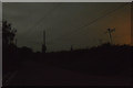
3
Cotleigh : Village Road
A road heading through Cotleigh with the moon in the sky above.
Image: © Lewis Clarke
Taken: 6 Sep 2017
0.10 miles
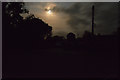
4

Cotleigh : Village Road
A road heading through Cotleigh seen with the light of the nearby telephone booth.
Image: © Lewis Clarke
Taken: 6 Sep 2017
0.11 miles
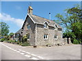
7
Old School House, Cotleigh
Still recognisable as the old school because of the bell tower. It is now a private residence.
Image: © Nigel Mykura
Taken: 7 Aug 2015
0.12 miles
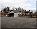
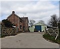
8

Cotleigh Recreation Ground
A large field with a children's play area , a carpark and also the village hall as well as the actual playing fields
Image: © Nigel Mykura
Taken: 7 Aug 2015
0.12 miles
10
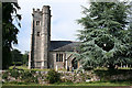
Cotleigh: St Michael?s church
The medieval dedication was to St Petroc – in 1293, but this was lost in the reformation. Looking north
Image: © Martin Bodman
Taken: 28 Jun 2006
0.16 miles