IMAGES TAKEN NEAR TO
Stockland, HONITON, EX14 9ES
Introduction
This page details the photographs taken nearby to EX14 9ES by members of the Geograph project.
The Geograph project started in 2005 with the aim of publishing, organising and preserving representative images for every square kilometre of Great Britain, Ireland and the Isle of Man.

There are currently over 7.5m images from over14,400 individuals and you can help contribute to the project by visiting https://www.geograph.org.uk
Image Map
Images are licensed for reuse under creativecommons.org/licenses/by-sa/2.0
Notes
- Clicking on the map will re-center to the selected point.
- The higher the marker number, the further away the image location is from the centre of the postcode.
Image Listing (12 Images Found)
Images are licensed for reuse under creativecommons.org/licenses/by-sa/2.0
Image
Details
Distance
1

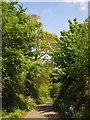
Lane to South Mill Farm
The lane from Ham runs beneath a tunnel of trees.
Image: © Derek Harper
Taken: 25 May 2013
0.05 miles
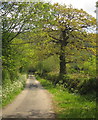
2

The Road To Stockland
This minor lane runs north out of the hamlet of ham towards the village of Stockland.
Image: © Nigel Mykura
Taken: 7 Aug 2015
0.07 miles
3

Pasture Field at Ham
Bright morning sunshine on an empty pasture field just north of the tiny village of Ham , just off the minor road to Stockland.
Image: © Nigel Mykura
Taken: 7 Aug 2015
0.16 miles
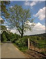
4
Lane north of Ham
Trees line the country lane as it heads towards South Mill Farm.
Image: © Derek Harper
Taken: 25 May 2013
0.17 miles
5
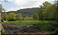
Towards the Corry Brook valley
From the lane between South Mill Farm and Boniford Cross, with Horner Hill across the valley.
Image: © Derek Harper
Taken: 25 May 2013
0.17 miles
6

Farmland, Ham
Beside the lane shown in Image], with a view across the Corry Brook valley to Horner Hill.
Image: © Derek Harper
Taken: 25 May 2013
0.17 miles
7

View towards Lower Ridge
From Beacon Hill.
Image: © Roger Cornfoot
Taken: 8 Nov 2017
0.18 miles
8
Lane north of Ham
A few metres further along the lane from which Image] was taken.
Image: © Derek Harper
Taken: 25 May 2013
0.20 miles
9
Lane to Boniford Cross
The lane from South Mill Farm drops past a freshly-leaved oak towards the Corry Brook. The lane is shown as wide on the 1:25000 sheet, which seems to assume that tarmac occupies the whole area between the hedgebanks.
Image: © Derek Harper
Taken: 25 May 2013
0.20 miles
10

Cottages at Ham
Looking along the lane north from the hamlet. On the right is The Old Smithy. At right angles to the lane up ahead is the listed thatched Myrtle Cottage http://list.english-heritage.org.uk/resultsingle.aspx?uid=1098412&searchtype=mapsearch .
Image: © Derek Harper
Taken: 25 May 2013
0.22 miles