IMAGES TAKEN NEAR TO
Stockland, HONITON, EX14 9EQ
Introduction
This page details the photographs taken nearby to EX14 9EQ by members of the Geograph project.
The Geograph project started in 2005 with the aim of publishing, organising and preserving representative images for every square kilometre of Great Britain, Ireland and the Isle of Man.

There are currently over 7.5m images from over14,400 individuals and you can help contribute to the project by visiting https://www.geograph.org.uk
Image Map
Images are licensed for reuse under creativecommons.org/licenses/by-sa/2.0
Notes
- Clicking on the map will re-center to the selected point.
- The higher the marker number, the further away the image location is from the centre of the postcode.
Image Listing (6 Images Found)
Images are licensed for reuse under creativecommons.org/licenses/by-sa/2.0
Image
Details
Distance
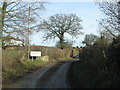
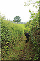
5
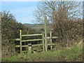
A stile marks the point where the footpath to Stockland leaves the road
Image: © Sarah Charlesworth
Taken: 3 Feb 2011
0.24 miles
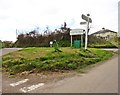
6
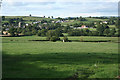
Stockland: at Longlands Cross
Looking north-north-east towards the village with the tower of St Michael’s church visible
Image: © Martin Bodman
Taken: 26 Aug 2006
0.24 miles