IMAGES TAKEN NEAR TO
Stockland, HONITON, EX14 9DX
Introduction
This page details the photographs taken nearby to EX14 9DX by members of the Geograph project.
The Geograph project started in 2005 with the aim of publishing, organising and preserving representative images for every square kilometre of Great Britain, Ireland and the Isle of Man.

There are currently over 7.5m images from over14,400 individuals and you can help contribute to the project by visiting https://www.geograph.org.uk
Image Map
Images are licensed for reuse under creativecommons.org/licenses/by-sa/2.0
Notes
- Clicking on the map will re-center to the selected point.
- The higher the marker number, the further away the image location is from the centre of the postcode.
Image Listing (7 Images Found)
Images are licensed for reuse under creativecommons.org/licenses/by-sa/2.0
Image
Details
Distance
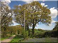
1
Country Lane near Hillgrounds
A very quiet rural lane with a few houses gathered at the edge of a large copse
Image: © Nigel Mykura
Taken: 7 Aug 2015
0.03 miles
3
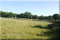
Fields near Hillgrounds
This pasture field complete with cattle is on the opposite side of the road from Hillgrounds.
Image: © Nigel Mykura
Taken: 7 Aug 2015
0.07 miles
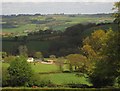
4
Barns at Hay Close Bungalow
From the lane descending to the Corry Brook valley, in the background. The barns are also shown in Image
Image: © Derek Harper
Taken: 16 May 2013
0.08 miles
5
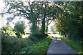
Lane to the Corry Brook
Bluebells and oaks beside the lane from Stockland Hill as it approaches the river crossing.
Image: © Derek Harper
Taken: 16 May 2013
0.16 miles
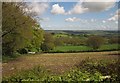
6
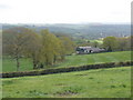
Farmland around Ashlands
From a lane junction on the east side of Stockland Hill, with the Yarty valley in the distance.
Image: © Derek Harper
Taken: 16 May 2013
0.17 miles
7
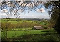
Fields near Hill Grounds
From the junction shown in Image], looking downhill to the Corry brook valley.
Image: © Derek Harper
Taken: 16 May 2013
0.22 miles