IMAGES TAKEN NEAR TO
Stockland, HONITON, EX14 9DS
Introduction
This page details the photographs taken nearby to EX14 9DS by members of the Geograph project.
The Geograph project started in 2005 with the aim of publishing, organising and preserving representative images for every square kilometre of Great Britain, Ireland and the Isle of Man.

There are currently over 7.5m images from over14,400 individuals and you can help contribute to the project by visiting https://www.geograph.org.uk
Image Map
Images are licensed for reuse under creativecommons.org/licenses/by-sa/2.0
Notes
- Clicking on the map will re-center to the selected point.
- The higher the marker number, the further away the image location is from the centre of the postcode.
Image Listing (29 Images Found)
Images are licensed for reuse under creativecommons.org/licenses/by-sa/2.0
Image
Details
Distance
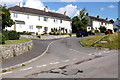
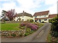
2
Battens, Stockland
Battens is a small residential road consisting mainly of bungalows with its own service road at the northern end of the village of Stockland opposite Walshams.
Image: © Nigel Mykura
Taken: 7 Aug 2015
0.05 miles
3
Walshams, Stockland.
Walshams is a small street of terraced houses on the northern edge of the village of Stockland just off the road to Yarcombe.
Image: © Nigel Mykura
Taken: 7 Aug 2015
0.07 miles
7
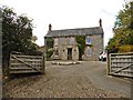
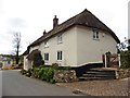
Houses ancient and modern, Stockland
Image: © Roger Cornfoot
Taken: 12 Apr 2017
0.10 miles
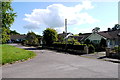
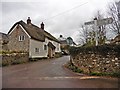
8

Junction in Stockland
At the heart of the village. Ahead is Yarcombe Road. Behind the camera is Churchway. On the left is Kite's Cottage, a "Circa 1500 hall house" http://list.english-heritage.org.uk/resultsingle.aspx?uid=1171310&searchtype=mapsearch . Opposite, behind the sign, King's Thatch, formerly a row of cottages http://list.english-heritage.org.uk/resultsingle.aspx?uid=1171319&searchtype=mapsearch .
Image: © Derek Harper
Taken: 25 May 2013
0.10 miles
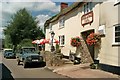
9
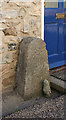
Old Bridge Marker, Stockland
Bridge Marker by the UC road, in parish of Stockland (East Devon District), opposite Kings Arms Inn, in village, 80m East of County Bridge, against wall of house.
surveyed
Milestone Society National ID: DV_SLHN01abr
Image: © Alan Rosevear
Taken: 2 Mar 2011
0.10 miles