IMAGES TAKEN NEAR TO
Stockland, HONITON, EX14 9DH
Introduction
This page details the photographs taken nearby to EX14 9DH by members of the Geograph project.
The Geograph project started in 2005 with the aim of publishing, organising and preserving representative images for every square kilometre of Great Britain, Ireland and the Isle of Man.

There are currently over 7.5m images from over14,400 individuals and you can help contribute to the project by visiting https://www.geograph.org.uk
Image Map
Images are licensed for reuse under creativecommons.org/licenses/by-sa/2.0
Notes
- Clicking on the map will re-center to the selected point.
- The higher the marker number, the further away the image location is from the centre of the postcode.
Image Listing (9 Images Found)
Images are licensed for reuse under creativecommons.org/licenses/by-sa/2.0
Image
Details
Distance
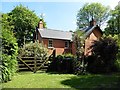
2
Cottage near Millhayes
Mellstock is at the top of a hill on the lane from Shore Bottom.
Image: © Derek Harper
Taken: 25 May 2013
0.01 miles
4
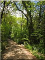
Bridge, Shore Bottom
The lane from Shore Bottom to Millhayes crosses a tiny tributary of the Corry Brook amid woodland.
Image: © Derek Harper
Taken: 25 May 2013
0.07 miles
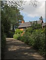
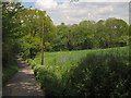
5
Track and lane, Shore Bottom
The lane from Shore Head to Millhayes is on the right; the track leads to houses tucked away in the woods in this side valley of the Corry Brook.
Image: © Derek Harper
Taken: 25 May 2013
0.13 miles
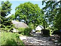
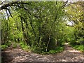
6
Approaching Shore Bottom
The lane running down the west side of the field shown in Image
Image: © Derek Harper
Taken: 25 May 2013
0.15 miles
7
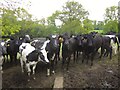
Bullocks, Millhayes
The first of three sets of frisky, inquisitive bullocks I met on this walk. These are on Stockland Footpath 12.
Image: © Derek Harper
Taken: 25 May 2013
0.21 miles
8
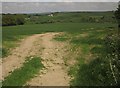
Arable field, Shore Head
A view through the field entrance shown in Image towards the Corry Brook and Lower and Higher Rodway Farms.
Image: © Derek Harper
Taken: 25 May 2013
0.21 miles
9

Field entrance and gate, Shore Head
From the lane to Millhayes, as it descends towards Shore Bottom. Across the Corry Brook are Lower and Higher Rodway Farms.
Image: © Derek Harper
Taken: 25 May 2013
0.21 miles