IMAGES TAKEN NEAR TO
Stockland, HONITON, EX14 9DD
Introduction
This page details the photographs taken nearby to EX14 9DD by members of the Geograph project.
The Geograph project started in 2005 with the aim of publishing, organising and preserving representative images for every square kilometre of Great Britain, Ireland and the Isle of Man.

There are currently over 7.5m images from over14,400 individuals and you can help contribute to the project by visiting https://www.geograph.org.uk
Image Map
Images are licensed for reuse under creativecommons.org/licenses/by-sa/2.0
Notes
- Clicking on the map will re-center to the selected point.
- The higher the marker number, the further away the image location is from the centre of the postcode.
Image Listing (16 Images Found)
Images are licensed for reuse under creativecommons.org/licenses/by-sa/2.0
Image
Details
Distance
1

Former chapel, Millhayes
The former chapel has long been converted to a private dwelling, although my (not especially ancient) 1:25000 map, and the current online version, still show it as a chapel, which is why I took a route that passed it.
Image: © Derek Harper
Taken: 25 May 2013
0.01 miles
2
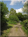
Lane junction, Millhayes
There's a maze of little lanes around here; these are two back lanes (both other routes with public access, the crossing lane being Mill Lane) meeting near Millhayes Cross.
Image: © Derek Harper
Taken: 25 May 2013
0.05 miles
3

House, Millhayes
On Mill Lane, as the route with public access approaches the mill at Millhayes.
Image: © Derek Harper
Taken: 25 May 2013
0.06 miles
4
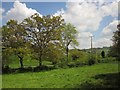
Fields in the Corry Brook valley
The brook flows behind the steel gate just visible across the next field left of centre. This view is from the stretch of Mill Lane shown in Image
Image: © Derek Harper
Taken: 25 May 2013
0.07 miles
5

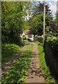
Mill Lane
The route with public access curves away from the cottage shown in Image] towards the Corry Brook crossing.
Image: © Derek Harper
Taken: 25 May 2013
0.08 miles
6

House, Millhayes
From the gate on Mill Lane shown in Image], with hens.
Image: © Derek Harper
Taken: 25 May 2013
0.09 miles
7
Mill Lane
The route with public access approaches Millhayes Mill.
Image: © Derek Harper
Taken: 25 May 2013
0.12 miles
8
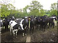
Bullocks, Millhayes
The first of three sets of frisky, inquisitive bullocks I met on this walk. These are on Stockland Footpath 12.
Image: © Derek Harper
Taken: 25 May 2013
0.12 miles
9
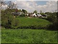
Lower Seavington Farm
Seen across meadows and the Corry Brook, from Mill Lane.
Image: © Derek Harper
Taken: 25 May 2013
0.13 miles
10
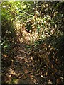
Blocked route, Millhayes
Mill Lane is a route with public access. Here a large number of cut tree branches make it difficult, but not quite impossible, to follow.
Image: © Derek Harper
Taken: 25 May 2013
0.18 miles