IMAGES TAKEN NEAR TO
Yarcombe, HONITON, EX14 9BH
Introduction
This page details the photographs taken nearby to EX14 9BH by members of the Geograph project.
The Geograph project started in 2005 with the aim of publishing, organising and preserving representative images for every square kilometre of Great Britain, Ireland and the Isle of Man.

There are currently over 7.5m images from over14,400 individuals and you can help contribute to the project by visiting https://www.geograph.org.uk
Image Map
Images are licensed for reuse under creativecommons.org/licenses/by-sa/2.0
Notes
- Clicking on the map will re-center to the selected point.
- The higher the marker number, the further away the image location is from the centre of the postcode.
Image Listing (8 Images Found)
Images are licensed for reuse under creativecommons.org/licenses/by-sa/2.0
Image
Details
Distance
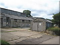
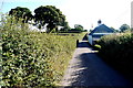
3
Lane through Hay Farm
Looking in the opposite direction from the same spot as Image
Image: © Derek Harper
Taken: 16 May 2013
0.19 miles
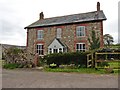
4
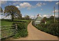
Grove Well Farmhouse
Just down the road from its farm buildings, this farmhouse is "probably late C16 - early C17" http://list.english-heritage.org.uk/resultsingle.aspx?uid=1333713&searchtype=mapsearch .
Image: © Derek Harper
Taken: 16 May 2013
0.19 miles
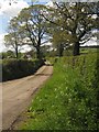
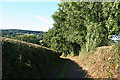
5
Rosshayne Lane
This lane climbs the southern flanks of Broadley Hill from Here near Grove Well Farm until it reaches Rosshayne Farm
Image: © Nigel Mykura
Taken: 7 Aug 2015
0.20 miles
6
Yarcombe: track leading to the village
Looking north-north-west on a public bridleway
Image: © Martin Bodman
Taken: 24 Aug 2006
0.22 miles
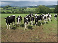
7
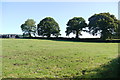
Field Next to Grove Well Farm
This pasture field is just north of the main farm buildings.
Image: © Nigel Mykura
Taken: 7 Aug 2015
0.22 miles