IMAGES TAKEN NEAR TO
Yarcombe, HONITON, EX14 9BE
Introduction
This page details the photographs taken nearby to EX14 9BE by members of the Geograph project.
The Geograph project started in 2005 with the aim of publishing, organising and preserving representative images for every square kilometre of Great Britain, Ireland and the Isle of Man.

There are currently over 7.5m images from over14,400 individuals and you can help contribute to the project by visiting https://www.geograph.org.uk
Image Map
Images are licensed for reuse under creativecommons.org/licenses/by-sa/2.0
Notes
- Clicking on the map will re-center to the selected point.
- The higher the marker number, the further away the image location is from the centre of the postcode.
Image Listing (8 Images Found)
Images are licensed for reuse under creativecommons.org/licenses/by-sa/2.0
Image
Details
Distance
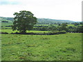
5
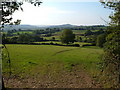
View from Yarcombe Footpath 19a
Looking towards Beacon Hill along the Yarty valley over the area of the Moorhayne farms south of Yarcombe.
Image: © Derek Harper
Taken: 21 Sep 2006
0.20 miles
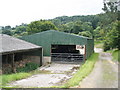
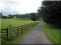
8
Yarcombe: track leading to the village
Looking north-north-west on a public bridleway
Image: © Martin Bodman
Taken: 24 Aug 2006
0.24 miles