IMAGES TAKEN NEAR TO
Pump Field Close, HONITON, EX14 4XX
Introduction
This page details the photographs taken nearby to Pump Field Close, EX14 4XX by members of the Geograph project.
The Geograph project started in 2005 with the aim of publishing, organising and preserving representative images for every square kilometre of Great Britain, Ireland and the Isle of Man.

There are currently over 7.5m images from over14,400 individuals and you can help contribute to the project by visiting https://www.geograph.org.uk
Image Map
Images are licensed for reuse under creativecommons.org/licenses/by-sa/2.0
Notes
- Clicking on the map will re-center to the selected point.
- The higher the marker number, the further away the image location is from the centre of the postcode.
Image Listing (4 Images Found)
Images are licensed for reuse under creativecommons.org/licenses/by-sa/2.0
Image
Details
Distance

2
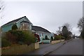
Housing in Highfield Road, Highwood
Part of a modern housing estate at Highwood near Dunkeswell
Image: © David Smith
Taken: 1 Jan 2015
0.19 miles
3
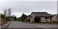
Catalina Close, Highwood
A cul-de-sac in this modern estate. The road takes its name from the wartime aircraft which operated from nearby Dunkeswell airfield
Image: © David Smith
Taken: 1 Jan 2015
0.21 miles
4
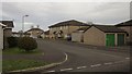
Azalea Close, Dunkeswell
Leading off Tower Way on this hilltop peddledash estate south of the old village.
Image: © Derek Harper
Taken: 14 Feb 2012
0.22 miles