IMAGES TAKEN NEAR TO
Manleys Lane, HONITON, EX14 4XQ
Introduction
This page details the photographs taken nearby to Manleys Lane, EX14 4XQ by members of the Geograph project.
The Geograph project started in 2005 with the aim of publishing, organising and preserving representative images for every square kilometre of Great Britain, Ireland and the Isle of Man.

There are currently over 7.5m images from over14,400 individuals and you can help contribute to the project by visiting https://www.geograph.org.uk
Image Map
Images are licensed for reuse under creativecommons.org/licenses/by-sa/2.0
Notes
- Clicking on the map will re-center to the selected point.
- The higher the marker number, the further away the image location is from the centre of the postcode.
Image Listing (72 Images Found)
Images are licensed for reuse under creativecommons.org/licenses/by-sa/2.0
Image
Details
Distance
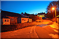
1
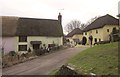
Thatched cottages, Dunkeswell
Corner Cottage and Wellsteps, the two cottages on the left, are listed http://www.britishlistedbuildings.co.uk/en-86587-corner-cottage-and-wellsteps-dunkeswell . The houses on the right are on the main road through the village.
Image: © Derek Harper
Taken: 14 Feb 2012
0.05 miles
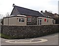
2
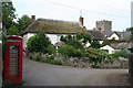
Dunkeswell: the village
Near the church, dedicated to St Nicholas, and looking north east
Image: © Martin Bodman
Taken: 29 Jun 2006
0.06 miles
4
Dunkeswell : Track
A track to the rear of properties in Dunkeswell.
Image: © Lewis Clarke
Taken: 23 Mar 2020
0.07 miles
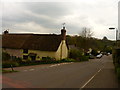
5
Dunkeswell : Village Road
A road through the village of Dunkeswell.
Image: © Lewis Clarke
Taken: 23 Mar 2020
0.08 miles

8
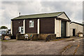
RAF Dunkeswell: a tour of a WW2 airfield - Fire Tender Shed (9)
A garage for a fire tender truck reserved for general fire fighting duties, and operated by the duty fire crew who were stationed in the guardhouse.
Image
Image: © Mike Searle
Taken: 7 May 2019
0.09 miles
9
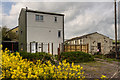
RAF Dunkeswell: a tour of a WW2 airfield - AML Bombing Teacher (7)
The Air Ministry Bombing Teacher building was for bomb aiming practice and training of aircraft bomb aimers. It appears to have since been converted to a private dwelling. For a full description of the operation of this and other sythetic trainers see https://www.historyofsimulation.com/flexible-gunnery-simulators/ https://media.geograph.org.uk/files/7eabe3a1649ffa2b3ff8c02ebfd5659f/vickers_bygrave_orig-original.jpg
Image
Image: © Mike Searle
Taken: 7 May 2019
0.09 miles
10
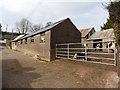
Farmyard in the centre of Dunkeswell
Image: © Roger Cornfoot
Taken: 23 Mar 2016
0.10 miles