IMAGES TAKEN NEAR TO
Beacon, HONITON, EX14 4TT
Introduction
This page details the photographs taken nearby to EX14 4TT by members of the Geograph project.
The Geograph project started in 2005 with the aim of publishing, organising and preserving representative images for every square kilometre of Great Britain, Ireland and the Isle of Man.

There are currently over 7.5m images from over14,400 individuals and you can help contribute to the project by visiting https://www.geograph.org.uk
Image Map
Images are licensed for reuse under creativecommons.org/licenses/by-sa/2.0
Notes
- Clicking on the map will re-center to the selected point.
- The higher the marker number, the further away the image location is from the centre of the postcode.
Image Listing (26 Images Found)
Images are licensed for reuse under creativecommons.org/licenses/by-sa/2.0
Image
Details
Distance
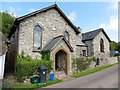
3
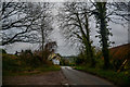
Beacon : Road
A road heading through the hamlet of Beacon.
Image: © Lewis Clarke
Taken: 5 Jan 2020
0.02 miles
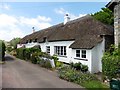
4
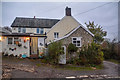
Luppitt: cottages at Beacon
Looking east-north-east. The row includes a converted chapel and a further structure beyond is undergoing a complete re-build
Image: © Martin Bodman
Taken: 28 Jun 2006
0.03 miles

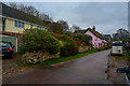
6
Beacon : Walley's Place
A house in Beacon.
Image: © Lewis Clarke
Taken: 5 Jan 2020
0.07 miles
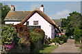
7
Beacon : Country Lane
A small lane heading through Beacon.
Image: © Lewis Clarke
Taken: 5 Jan 2020
0.09 miles
8
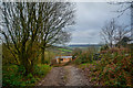
Beacon : Track
A track heading down into Beacon.
Image: © Lewis Clarke
Taken: 5 Jan 2020
0.10 miles
9
Luppitt : Track
A track heading through the Luppitt parish.
Image: © Lewis Clarke
Taken: 5 Jan 2020
0.10 miles
10

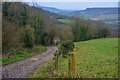
Luppitt : Track
A track heads through the countryside.
Image: © Lewis Clarke
Taken: 5 Jan 2020
0.12 miles