IMAGES TAKEN NEAR TO
Luppitt, HONITON, EX14 4SX
Introduction
This page details the photographs taken nearby to EX14 4SX by members of the Geograph project.
The Geograph project started in 2005 with the aim of publishing, organising and preserving representative images for every square kilometre of Great Britain, Ireland and the Isle of Man.

There are currently over 7.5m images from over14,400 individuals and you can help contribute to the project by visiting https://www.geograph.org.uk
Image Map
Images are licensed for reuse under creativecommons.org/licenses/by-sa/2.0
Notes
- Clicking on the map will re-center to the selected point.
- The higher the marker number, the further away the image location is from the centre of the postcode.
Image Listing (3 Images Found)
Images are licensed for reuse under creativecommons.org/licenses/by-sa/2.0
Image
Details
Distance
1
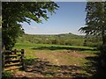
View over the Luppitt valley
A view through the gateway visible beneath the oak trees in Image
Image: © Derek Harper
Taken: 22 May 2012
0.09 miles
2
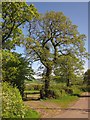
Oaks by the lane from Luppitt
Oaks with fresh leaves over a gate into a pasture by the winding lane descending the west side of the valley.
Image: © Derek Harper
Taken: 22 May 2012
0.11 miles
3
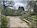
Ford at Luppitt
This is another ford at Luppitt. One of four.
Image: © John Walton
Taken: 1 May 2021
0.20 miles