IMAGES TAKEN NEAR TO
Luppitt, HONITON, EX14 4SU
Introduction
This page details the photographs taken nearby to EX14 4SU by members of the Geograph project.
The Geograph project started in 2005 with the aim of publishing, organising and preserving representative images for every square kilometre of Great Britain, Ireland and the Isle of Man.

There are currently over 7.5m images from over14,400 individuals and you can help contribute to the project by visiting https://www.geograph.org.uk
Image Map
Images are licensed for reuse under creativecommons.org/licenses/by-sa/2.0
Notes
- Clicking on the map will re-center to the selected point.
- The higher the marker number, the further away the image location is from the centre of the postcode.
Image Listing (6 Images Found)
Images are licensed for reuse under creativecommons.org/licenses/by-sa/2.0
Image
Details
Distance
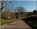
1
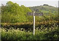
Luppitt : Country Lane
A small country lane at the road junction.
Image: © Lewis Clarke
Taken: 31 Dec 2022
0.07 miles
2
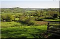
View over the Luppitt valley
Looking down the valley from the lane west of the village and of Mountstephens Cross.
Image: © Derek Harper
Taken: 22 May 2012
0.11 miles
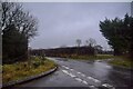
4
Ringborough Cross
The signpost at a lane junction a steep climb above Luppitt village, with a glimpse of the distant Dumpdon Hill behind.
Image: © Derek Harper
Taken: 22 May 2012
0.21 miles
5

Luppitt, St. Mary's Church: Celebrated oak crossing roof 2
Image: © Michael Garlick
Taken: 3 Apr 2018
0.23 miles