IMAGES TAKEN NEAR TO
Luppitt, HONITON, EX14 4SN
Introduction
This page details the photographs taken nearby to EX14 4SN by members of the Geograph project.
The Geograph project started in 2005 with the aim of publishing, organising and preserving representative images for every square kilometre of Great Britain, Ireland and the Isle of Man.

There are currently over 7.5m images from over14,400 individuals and you can help contribute to the project by visiting https://www.geograph.org.uk
Image Map
Images are licensed for reuse under creativecommons.org/licenses/by-sa/2.0
Notes
- Clicking on the map will re-center to the selected point.
- The higher the marker number, the further away the image location is from the centre of the postcode.
Image Listing (8 Images Found)
Images are licensed for reuse under creativecommons.org/licenses/by-sa/2.0
Image
Details
Distance
1

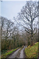
Luppitt : Country Lane
The country lane splits into two.
Image: © Lewis Clarke
Taken: 5 Jan 2020
0.10 miles
2
Luppitt : Country Lane
Looking along a small lane.
Image: © Lewis Clarke
Taken: 5 Jan 2020
0.13 miles
3
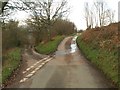
Lane junction, Hartridge
A fork in the unfenced road along the west side of the steep hillside. The left fork heads down and across the valley for Luppitt; straight on continues along the hillside, steadily climbing towards the plateau summit.
Image: © Derek Harper
Taken: 26 Jan 2012
0.15 miles
4

Luppitt : Country Lane
Looking along a small lane.
Image: © Lewis Clarke
Taken: 5 Jan 2020
0.15 miles
5

Luppitt : Country Lane
A small lane heading through the countryside.
Image: © Lewis Clarke
Taken: 5 Jan 2020
0.15 miles

7

Luppitt : Country Lane
A small lane heading through the Luppitt parish.
Image: © Lewis Clarke
Taken: 5 Jan 2020
0.19 miles
8

Farms below Hartridge
Looking across the Luppitt valley from the point where Image was taken. Below the steep slope of Hartridge Common are Shelf Farm (left) and, confusingly, Shelves Farm (right). The nearer cluster of buildings are around Littletown and Barnfield Farms.
Image: © Derek Harper
Taken: 22 May 2012
0.23 miles