IMAGES TAKEN NEAR TO
Dunkeswell, HONITON, EX14 4SH
Introduction
This page details the photographs taken nearby to EX14 4SH by members of the Geograph project.
The Geograph project started in 2005 with the aim of publishing, organising and preserving representative images for every square kilometre of Great Britain, Ireland and the Isle of Man.

There are currently over 7.5m images from over14,400 individuals and you can help contribute to the project by visiting https://www.geograph.org.uk
Image Map
Images are licensed for reuse under creativecommons.org/licenses/by-sa/2.0
Notes
- Clicking on the map will re-center to the selected point.
- The higher the marker number, the further away the image location is from the centre of the postcode.
Image Listing (12 Images Found)
Images are licensed for reuse under creativecommons.org/licenses/by-sa/2.0
Image
Details
Distance
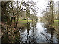
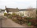
2
Dunkeswell : Lakeside Manor
A road leading up towards Lakeside Manor.
Image: © Lewis Clarke
Taken: 23 Mar 2020
0.07 miles
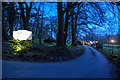
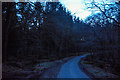
3
Dunkeswell : Country Lane
Looking along a small country lane.
Image: © Lewis Clarke
Taken: 23 Mar 2020
0.09 miles
6
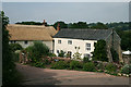
Dunkeswell: Southlands Farm
By a hairpin bend and overlooking the Madford valley, looking north-north-west
Image: © Martin Bodman
Taken: 29 Jun 2006
0.09 miles
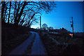
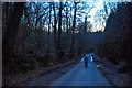
7
Dunkeswell : Country Lane
Looking along a country lane.
Image: © Lewis Clarke
Taken: 23 Mar 2020
0.11 miles
8
Dunkeswell : Country Lane
Looking along a small country lane.
Image: © Lewis Clarke
Taken: 23 Mar 2020
0.12 miles
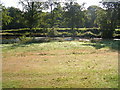
9
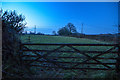
Dunkeswell : Grassy Field & Gate
Looking into a field beyond a gate.
Image: © Lewis Clarke
Taken: 23 Mar 2020
0.12 miles
10
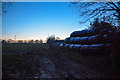
Clayhidon : Grassy Field & Gate
Looking into a grassy field beyond a gate.
Image: © Lewis Clarke
Taken: 23 Mar 2020
0.15 miles