IMAGES TAKEN NEAR TO
Combe Raleigh, HONITON, EX14 4SG
Introduction
This page details the photographs taken nearby to EX14 4SG by members of the Geograph project.
The Geograph project started in 2005 with the aim of publishing, organising and preserving representative images for every square kilometre of Great Britain, Ireland and the Isle of Man.

There are currently over 7.5m images from over14,400 individuals and you can help contribute to the project by visiting https://www.geograph.org.uk
Image Map
Images are licensed for reuse under creativecommons.org/licenses/by-sa/2.0
Notes
- Clicking on the map will re-center to the selected point.
- The higher the marker number, the further away the image location is from the centre of the postcode.
Image Listing (5 Images Found)
Images are licensed for reuse under creativecommons.org/licenses/by-sa/2.0
Image
Details
Distance
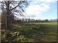
1
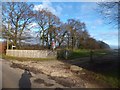
Public footpath to Hill Farm
On the hilltop, the farm access road is screened by trees
Image: © David Smith
Taken: 28 Nov 2012
0.04 miles
3
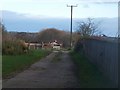
Hill Farm
The farm buildings are set below the highest point on the hill
Image: © David Smith
Taken: 28 Nov 2012
0.15 miles
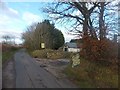
4
Awliscombe: boundary with Combe Raleigh
Looking north along the lane on the hill that separates the two parishes. Rose bay willow herb, known by some as fireweed, still flowers in the bank
Image: © Martin Bodman
Taken: 7 Sep 2005
0.17 miles
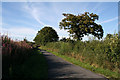
5
An old broad track to Farm Cleave
One thinks of Kipling's poem: "They shut the road through the woods ... And now you would never know There was once a road through the woods"
Image: © David Smith
Taken: 28 Nov 2012
0.22 miles