IMAGES TAKEN NEAR TO
Dunkeswell, HONITON, EX14 4SD
Introduction
This page details the photographs taken nearby to EX14 4SD by members of the Geograph project.
The Geograph project started in 2005 with the aim of publishing, organising and preserving representative images for every square kilometre of Great Britain, Ireland and the Isle of Man.

There are currently over 7.5m images from over14,400 individuals and you can help contribute to the project by visiting https://www.geograph.org.uk
Image Map
Images are licensed for reuse under creativecommons.org/licenses/by-sa/2.0
Notes
- Clicking on the map will re-center to the selected point.
- The higher the marker number, the further away the image location is from the centre of the postcode.
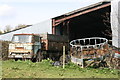
Image Listing (18 Images Found)
Images are licensed for reuse under creativecommons.org/licenses/by-sa/2.0
Image
Details
Distance
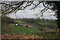
5
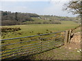
Valley above Abbey
Very similar to Image, but including Abbey Wood to the left.
Image: © Derek Harper
Taken: 14 Feb 2012
0.05 miles
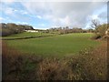
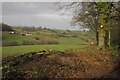
6
Abbey Wood
Seen from Dunkeswell Footpath 15, the path shown in Image, beside Acre Pit, and looking across the valley shown in Image
Image: © Derek Harper
Taken: 14 Feb 2012
0.05 miles
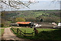
8

Burnsome Cottage
The cottage viewed distantly from the lane from Dunkeswell, a view that looks as if it would have been impossible before the recent felling of some trees.
Image: © Derek Harper
Taken: 14 Feb 2012
0.11 miles