IMAGES TAKEN NEAR TO
Abbey Road, HONITON, EX14 4RL
Introduction
This page details the photographs taken nearby to Abbey Road, EX14 4RL by members of the Geograph project.
The Geograph project started in 2005 with the aim of publishing, organising and preserving representative images for every square kilometre of Great Britain, Ireland and the Isle of Man.

There are currently over 7.5m images from over14,400 individuals and you can help contribute to the project by visiting https://www.geograph.org.uk
Image Map
Images are licensed for reuse under creativecommons.org/licenses/by-sa/2.0
Notes
- Clicking on the map will re-center to the selected point.
- The higher the marker number, the further away the image location is from the centre of the postcode.
Image Listing (62 Images Found)
Images are licensed for reuse under creativecommons.org/licenses/by-sa/2.0
Image
Details
Distance
1
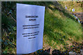
Dunkeswell : Layby
A layby with a sign warning people to clean up after their dog.
Image: © Lewis Clarke
Taken: 23 Mar 2020
0.02 miles
2
Dunkeswell : Dee Cut
Dee Cut in Dunkeswell.
Image: © Lewis Clarke
Taken: 23 Mar 2020
0.04 miles
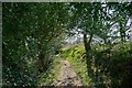
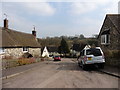
3

Dunkeswell : Country Lane
A country Lane heading out from Dunkeswell.
Image: © Lewis Clarke
Taken: 23 Mar 2020
0.04 miles
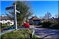
5

Dunkeswell: The path to St. Nicholas' Church
Image: © Michael Garlick
Taken: 3 Apr 2018
0.05 miles
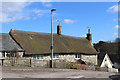
6
Dunkeswell : Footpath
A footpath heading towards Dunkeswell.
Image: © Lewis Clarke
Taken: 23 Mar 2020
0.06 miles
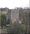

10
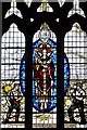
Dunkeswell, St. Nicholas' Church: Stained glass window
Image: © Michael Garlick
Taken: 3 Apr 2018
0.07 miles