IMAGES TAKEN NEAR TO
Flightway, Dunkeswell Business Park, HONITON, EX14 4RD
Introduction
This page details the photographs taken nearby to Flightway, Dunkeswell Business Park, EX14 4RD by members of the Geograph project.
The Geograph project started in 2005 with the aim of publishing, organising and preserving representative images for every square kilometre of Great Britain, Ireland and the Isle of Man.

There are currently over 7.5m images from over14,400 individuals and you can help contribute to the project by visiting https://www.geograph.org.uk
Image Map
Images are licensed for reuse under creativecommons.org/licenses/by-sa/2.0
Notes
- Clicking on the map will re-center to the selected point.
- The higher the marker number, the further away the image location is from the centre of the postcode.
Image Listing (53 Images Found)
Images are licensed for reuse under creativecommons.org/licenses/by-sa/2.0
Image
Details
Distance
1
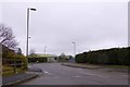
Flightway Business Park, Dunkeswell
A business park that is built on the level space occupied during WW2 by an airfield
Image: © David Smith
Taken: 1 Jan 2015
0.12 miles
2
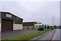
Two industrial units in the business park at Dunkeswell
Image: © David Smith
Taken: 1 Jan 2015
0.13 miles
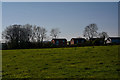
3

Dunkeswell: near Hutshayes Farm
Looking south east
Image: © Martin Bodman
Taken: 23 May 2006
0.15 miles
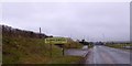
4

Dunkeswell : Road
A road heads out from the business park.
Image: © Lewis Clarke
Taken: 8 Feb 2022
0.16 miles
5

Dunkeswell : Country Lane
A country Lane heading out from Dunkeswell.
Image: © Lewis Clarke
Taken: 23 Mar 2020
0.17 miles
6
Dunkeswell : Grassy Field
A grassy field in the Dunkeswell parish.
Image: © Lewis Clarke
Taken: 23 Mar 2020
0.19 miles
7

Dunkeswell Air Centre
A friendly welcome awaits visiting pilots or public.
The centre is situated on the old wartime airfield, which was originally planned in 1943 to station Fighter Command, then Coastal Command, but was eventually used by American forces. The 479th Anti Submarine Group were first to fly from here, but the current buildings are well-decorated by paintings and pictures of the Liberators based here in the later stages of the war.
Image: © Neil Owen
Taken: 20 Mar 2011
0.19 miles
8
Welcome to Dunkeswell
Sign at the edge of the village; the road is passing the end of a runway for the Dunkeswell airfield. Formerly, one runway of this WW2 airfield extended across the road, beyond the footpath on the left.
Image: © David Smith
Taken: 1 Jan 2015
0.19 miles
9
Dunkeswell : Layby
A layby with a sign warning people to clean up after their dog.
Image: © Lewis Clarke
Taken: 23 Mar 2020
0.19 miles
