IMAGES TAKEN NEAR TO
Sheldon, HONITON, EX14 4QR
Introduction
This page details the photographs taken nearby to EX14 4QR by members of the Geograph project.
The Geograph project started in 2005 with the aim of publishing, organising and preserving representative images for every square kilometre of Great Britain, Ireland and the Isle of Man.

There are currently over 7.5m images from over14,400 individuals and you can help contribute to the project by visiting https://www.geograph.org.uk
Image Map
Images are licensed for reuse under creativecommons.org/licenses/by-sa/2.0
Notes
- Clicking on the map will re-center to the selected point.
- The higher the marker number, the further away the image location is from the centre of the postcode.
Image Listing (9 Images Found)
Images are licensed for reuse under creativecommons.org/licenses/by-sa/2.0
Image
Details
Distance
1
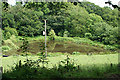
Sheldon: pond near Southcott Farm
Looking east-north-east
Image: © Martin Bodman
Taken: 29 Jun 2006
0.04 miles
6
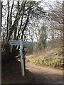
The sign at Southcott Cross
Only two roads have directions. The track beyond the sign is a farm track, and opposite is a minor road to Southcott
Image: © David Smith
Taken: 4 Mar 2013
0.14 miles
8
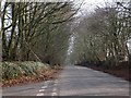
Golden Lane from Southcott Cross
A road with hedgebanks whose trees have grown
Image: © David Smith
Taken: 4 Mar 2013
0.17 miles
