IMAGES TAKEN NEAR TO
Flightway, Dunkeswell Business Park, HONITON, EX14 4PE
Introduction
This page details the photographs taken nearby to Flightway, Dunkeswell Business Park, EX14 4PE by members of the Geograph project.
The Geograph project started in 2005 with the aim of publishing, organising and preserving representative images for every square kilometre of Great Britain, Ireland and the Isle of Man.

There are currently over 7.5m images from over14,400 individuals and you can help contribute to the project by visiting https://www.geograph.org.uk
Image Map
Images are licensed for reuse under creativecommons.org/licenses/by-sa/2.0
Notes
- Clicking on the map will re-center to the selected point.
- The higher the marker number, the further away the image location is from the centre of the postcode.
Image Listing (70 Images Found)
Images are licensed for reuse under creativecommons.org/licenses/by-sa/2.0
Image
Details
Distance

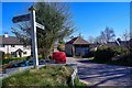
2

Dunkeswell : Country Lane
A country Lane heading out from Dunkeswell.
Image: © Lewis Clarke
Taken: 23 Mar 2020
0.09 miles
3
RAF Dunkeswell: a tour of a WW2 airfield - Fire Tender Shed (9)
A garage for a fire tender truck reserved for general fire fighting duties, and operated by the duty fire crew who were stationed in the guardhouse.
Image
Image: © Mike Searle
Taken: 7 May 2019
0.09 miles
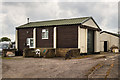
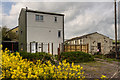
4
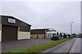
Two industrial units in the business park at Dunkeswell
Image: © David Smith
Taken: 1 Jan 2015
0.10 miles
5
Dunkeswell : Dee Cut
Dee Cut in Dunkeswell.
Image: © Lewis Clarke
Taken: 23 Mar 2020
0.10 miles

7
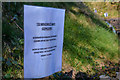
Dunkeswell : Layby
A layby with a sign warning people to clean up after their dog.
Image: © Lewis Clarke
Taken: 23 Mar 2020
0.11 miles
8
RAF Dunkeswell: a tour of a WW2 airfield - AML Bombing Teacher (7)
The Air Ministry Bombing Teacher building was for bomb aiming practice and training of aircraft bomb aimers. It appears to have since been converted to a private dwelling. For a full description of the operation of this and other sythetic trainers see https://www.historyofsimulation.com/flexible-gunnery-simulators/ https://media.geograph.org.uk/files/7eabe3a1649ffa2b3ff8c02ebfd5659f/vickers_bygrave_orig-original.jpg
Image
Image: © Mike Searle
Taken: 7 May 2019
0.12 miles
9
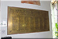
Plaque for American servicemen in Dunkeswell church
Image: © Nick Chipchase
Taken: 25 Mar 2016
0.12 miles
10
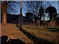
Dunkeswell : St Nicholas Church
Looking towards the church in Dunkeswell.
Image: © Lewis Clarke
Taken: 23 Mar 2020
0.12 miles