IMAGES TAKEN NEAR TO
Awliscombe, HONITON, EX14 3NS
Introduction
This page details the photographs taken nearby to EX14 3NS by members of the Geograph project.
The Geograph project started in 2005 with the aim of publishing, organising and preserving representative images for every square kilometre of Great Britain, Ireland and the Isle of Man.

There are currently over 7.5m images from over14,400 individuals and you can help contribute to the project by visiting https://www.geograph.org.uk
Image Map
Images are licensed for reuse under creativecommons.org/licenses/by-sa/2.0
Notes
- Clicking on the map will re-center to the selected point.
- The higher the marker number, the further away the image location is from the centre of the postcode.
Image Listing (6 Images Found)
Images are licensed for reuse under creativecommons.org/licenses/by-sa/2.0
Image
Details
Distance
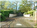
1

A373 near Awliscombe House
From the end of Winneford Lane, with a lane up to Limer's Cross on the other side of the main road.
Image: © Derek Harper
Taken: 26 Jan 2012
0.03 miles
3
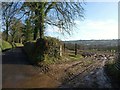
Lane and field entrance near Awliscombe House
The muddy field entrance gives a view of Honiton. The lane runs to Tracey.
Image: © Derek Harper
Taken: 26 Jan 2012
0.09 miles
4

Towards Allington
A view from the corner where Image was taken, on the slopes of St Cyres' Hill.
Image: © Derek Harper
Taken: 26 Jan 2012
0.12 miles
5
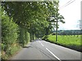
Looking east to the valley of the River Otter
The A373 and the flat landscape of the wide river valley
Image: © David Smith
Taken: 20 Aug 2012
0.17 miles
6
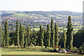
Awliscombe: south to Honiton
The western end of the town seen from the road that climbs St Cyres’ Hill
Image: © Martin Bodman
Taken: 7 Sep 2005
0.24 miles