IMAGES TAKEN NEAR TO
Broadhembury, HONITON, EX14 3LD
Introduction
This page details the photographs taken nearby to EX14 3LD by members of the Geograph project.
The Geograph project started in 2005 with the aim of publishing, organising and preserving representative images for every square kilometre of Great Britain, Ireland and the Isle of Man.

There are currently over 7.5m images from over14,400 individuals and you can help contribute to the project by visiting https://www.geograph.org.uk
Image Map
Images are licensed for reuse under creativecommons.org/licenses/by-sa/2.0
Notes
- Clicking on the map will re-center to the selected point.
- The higher the marker number, the further away the image location is from the centre of the postcode.
Image Listing (6 Images Found)
Images are licensed for reuse under creativecommons.org/licenses/by-sa/2.0
Image
Details
Distance
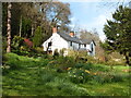
1
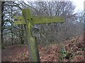
Footpath to Hembury Fort
Christmas day picnic !
Image: © john spivey
Taken: 25 Dec 2003
0.07 miles
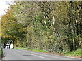
2
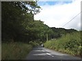
A373 on the slope of Hembury Fort
The road climbs to pass to the south of the Iron Age fort, which is surrounded by the trees on the right
Image: © David Smith
Taken: 20 Aug 2012
0.15 miles
3
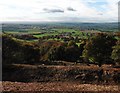
View to the south from Hembury Hill Fort
Image: © Roger Cornfoot
Taken: 2 Nov 2016
0.18 miles
4
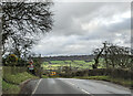
Steep downhill and sharp bend on the A373, heading east
Image: © Rob Purvis
Taken: 2 Feb 2023
0.21 miles
6
The A373 passes the tree-covered Hembury Fort
Image: © Sarah Charlesworth
Taken: 30 Oct 2010
0.24 miles