IMAGES TAKEN NEAR TO
Payhembury, HONITON, EX14 3JQ
Introduction
This page details the photographs taken nearby to EX14 3JQ by members of the Geograph project.
The Geograph project started in 2005 with the aim of publishing, organising and preserving representative images for every square kilometre of Great Britain, Ireland and the Isle of Man.

There are currently over 7.5m images from over14,400 individuals and you can help contribute to the project by visiting https://www.geograph.org.uk
Image Map
Images are licensed for reuse under creativecommons.org/licenses/by-sa/2.0
Notes
- Clicking on the map will re-center to the selected point.
- The higher the marker number, the further away the image location is from the centre of the postcode.
Image Listing (6 Images Found)
Images are licensed for reuse under creativecommons.org/licenses/by-sa/2.0
Image
Details
Distance

3
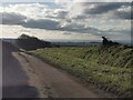
Payhembury : Country Lane
Looking along a small lane.
Image: © Lewis Clarke
Taken: 6 Dec 2022
0.23 miles
4
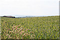
Payhembury: wheat field
Looking west near Rull
Image: © Martin Bodman
Taken: 24 Jun 2006
0.25 miles
5
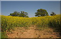
Oilseed rape near Rull
From the lane east of Spence Cross, with oak trees along a field boundary up the hill.
Image: © Derek Harper
Taken: 22 May 2012
0.25 miles
6

Payhembury: wheat field
Looking east-south-east near Rull
Image: © Martin Bodman
Taken: 24 Jun 2006
0.25 miles